If your Friday night included a marathon of terrible Chinese martial arts movies on Netflix, (or even some good ones like Crouching Tiger, Hidden Dragon and House of Flying Daggers), you will undoubtedly feel compelled to find some type of mystical bamboo forest when you wake up Saturday morning.
Fortunately, if you are in North Carolina, you are in luck. While two of the native bamboo species are short scrubby switchcanes, the last, Arundinaria gigantea, (coming in at over 33 feet in height when mature), is truly a worthy backdrop for flying ninjas and hanbok wearing assassins. Even better, a reasonable forest of these majestic giants (or a similar species), can be found at Eno River State Park, where once you’re done cruising the bamboo you can also check out a few other interesting destinations.
[This excellent hike would not have been possible without the great maps at http://enotrails.com/ . Check it out!]
Location: Eno River State Park. The section adjacent to I-85.
Is it goat approved? If the goat is on leash, can cross water, and handle close passes by people, then yes, this park is goat agreeable. Park rangers regularly patrol the trails around the quarry, so keep the goat on leash in this area at all costs. The park, like other sections of the Eno River, doesn’t seem to get many visitors before 11:30 on Saturdays in cold weather.
How you get there: Exit 170 off 85 near Durham. After taking the exit, be prepared for some insanity – this intersection is very oddly set up. Watch for the Eno River State Park brown signs. Remember that you want to leave on the north side of the highway, and that you want to head north to the park, and you may need to go through several mini-intersections in the area right around the intersection with I-85 to get there. You may need to turn around a few times before you get going correctly. The parking area is right off Pleasant Green Road, before you cross Eno River if you are coming from I-85. There will be a small sign and gravel road on your left just before the bridge over the river.

Time for hike: Something like 6 miles round trip. This is a loop hike.
Best season to do this hike: WINTER, preferably the coldest most miserable day possible. Avoid this area during the summer as the quarry is a popular (if discouraged) swimming hole.
Trails to Take

Start off in the parking lot. As a little prequel to the main hike there’s a small trail leading towards one of those big metal power line poles. In this area are some ruins for the old power station that used to use the nearby pond for water which are fun to explore.
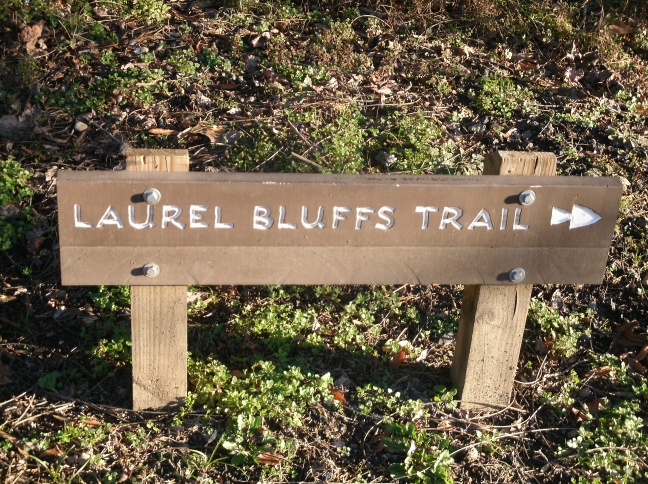
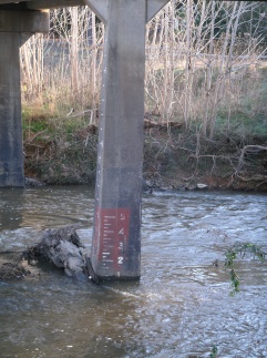
The main trail out is Laurel Ridge Trail, which is also a section of the MST. The MST is the “Mountains to the Sea Trail”, which exemplifies the typical Southern mentality of no nonsense naming. It is exactly what it says it is, a very long trail running from the mountains of North Carolina to the Outerbanks. Walk across the parking lot towards the entrance to the parking area. A brown sign will direct you to Laurel Ridge Trail on your right. The trail runs under the bridge. As the Eno River is prone to flooding during major weather events they have a handy water height measurement painted on the bridge that can be entertaining to watch during bad weather.

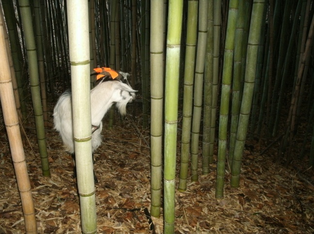
The trail runs through open woods and eventually ascends up into the hill country around Eno River. There’s some nice twists and turns and a picturesque creek crossing. When you reach the wooden bridge, look to your right to see the awesome bamboo forest, which is perfectly visible in winter. If you go in the summer and can’t see the forest, follow the small stream up hill and that runs directly into the forest. Bamboo forests have extremely dense canopies and can be very dark inside. If the day is overcast consider bringing a flashlight to explore the forest and a camera with good flash! There is what appears to have been an old spring cover next to the creek I almost fell over too.


Once you’re done playing ninja in the forest, continue on the trail. It will eventually come up past a pile of grey boulders that are obvious from the quarry, and shortly afterwards you’ll see the quarry. According to Ye Olde Internet this quarry is something like 80 ft deep, but has extremely vertical sides. Therefore, unlike its more impressive brethren, this quarry just looks like a small pond…until you start really looking at the water and realize that it is literally a drop off from the shore line right down all 80 ft. Apparently there is enough debris and fallen stone at the bottom of this quarry that doing the old quarry cliff dive maneuver can be lethal. Of course, as any one who survived high school knows, people still jump in it anyway. They even built a special road for ambulances to get up to the quarry on the southwest side.


Go left to go around the quarry on the river side. About half way around the trail will come off the edge of the quarry and cross a small river. There are excellent step stones here, but the water is swift and deep-ish if you fall off so bring the goat who is comfortable and won’t balk at the thought of getting a little wet.


Quarry trail then continues along and up a hill. At the top of the hill you will see a large ditch come in on your right, swing around, and then the trail will walk into the ditch and climb back out. This “ditch” is the very old Fish Dam Road which was once the sole through fare for the area. The original road dates back to a Native American trading path. Where the trail crosses the road you will see to your right a smaller road come off the massive Fish Dam Road ditch. This is the access road to the Cabe Mill, amazingly still visible after so many years of abandonment. As you continue down the trail for much of the way you will see this access road running to your right. Eventually you will need to turn left onto Cabe Lands Trail.

The trail goes down hill to the river. At the point the trail turns and runs along the river look to your right to see the opening of the raceway that brought water from the river down to the Cabe Mill. This raceway is incredibly long, and as you walk you will see it continue, in places even still stone lined, until you reach the mill.

The mill itself is visible to your right up against the distant hillside as you cross the first of two wooden bridges. The first bridge crosses the outlet of the raceway, (after the water had left the mill it flowed from here back into the river), and the second crosses a creek.

The trail then runs up hill, past the old Cabe Homestead, (which is no longer visible even as ruins), and then watch for Laurel Ridge Trail/MST to go off to your left. Take this trail, and keep a sharp lookout for an obvious foot path that is without a trail sign. This leads to the old Cabe cemetery.
After checking out the cemetery, continue past it down to the parking lot, get back on Cabe Lands Trail, and go back around Cabe Lands Trail to Quarry Trail, over the water crossing, and back to the quarry. If you came in near the river, check out the rest of the quarry edge by going to your left here. This takes you along a fun little trail between the edge of the quarry and the creek, passes a spring area, and even takes you around past the ambulance driveway. The original road into the quarry is visible in places.
Eventually you end back up where the MST/Laurel Ridge Trail came in and can take that back out to the car, with a short stop again to enjoy the bambooey awesomeness.

Be Warned!
- Theft from parked cars is common throughout the Eno River system. You are in Durham, so expect to hide your valuables and consider if pepper spray is right for you.
- Get off the trail by 11:30 at the latest (ideally 11:00) in the winter. If you do this when the weather is really cold you can walk pretty much the whole park and meet few if any other people.
- Eno River rises A LOT during major flood periods (such as hurricanes). Therefore, big storms, hurricanes, etc. may not be the ideal time to go on this hike by the river. The water crossing at the quarry may not be passable.
- Deer hunting is popular throughout North Carolina. If you are visiting from September – December consider coating your goat and yourself with orange if you plan to visit the off trail locations.
- Ruins are not safe! Duh! So don’t be like climbing and parkoring off them and stuff. Also be careful of old wells and cellars that may not be well covered in the vicinity of abandoned industrial sites. Lassie might save Timmy if he falls down a well, but a goat is more likely to give you up for dead and go find something to eat.
- Park rangers regularly patrol the trails around the quarry, so keep the goat on leash in this area at all costs.
In Sum: If you shake a bunch of bamboo really hard…does a ninja fall out?
