Want a nice scenic hike with some interesting water crossings to a lovely lake side campground? Or want a death defying mountain climb through obvious bear country with minimal trail markers and peat bogs that suck you, (but not the goat who is much smarter than you), in? You can choose, or if you are really crazy, try both!
Location: High Peaks Region of the Adirondacks (New York State)
Is it goat approved? Not exactly. These are foot trails, so be happy that goats live in a little place I like to call “Limbo” right now with the Park Service. Respect other users and be ingratiating and maybe we can all stay in Limbo permanently.
How to get there: Start at the Tahawus mine trail head, which is just beyond a blast furnace and the ghost town that once belonged to this now closed iron/titanium mine. Excellent parking with a gravel lot.
Time for the hike: For the “hard way”, I started at 9 am, reached campground at dusk, passed out, and took about 3 hrs slowly limping back out the next day. This hike is a loop.
Directions to Trail Head: Exit 29 (from I-87) turning W onto Blue Ridge Road, Rte 84. Follow this route for 17.4 miles to an intersection with Tahawus Rd. (CR 25). Turn right for 6.3 miles and then left at a sign for High Peaks Trails. The blast furnace is 2.8 miles up this road. (Road right and across a bridge leads to the old mining area, which is closed to the public).
Trails to Take
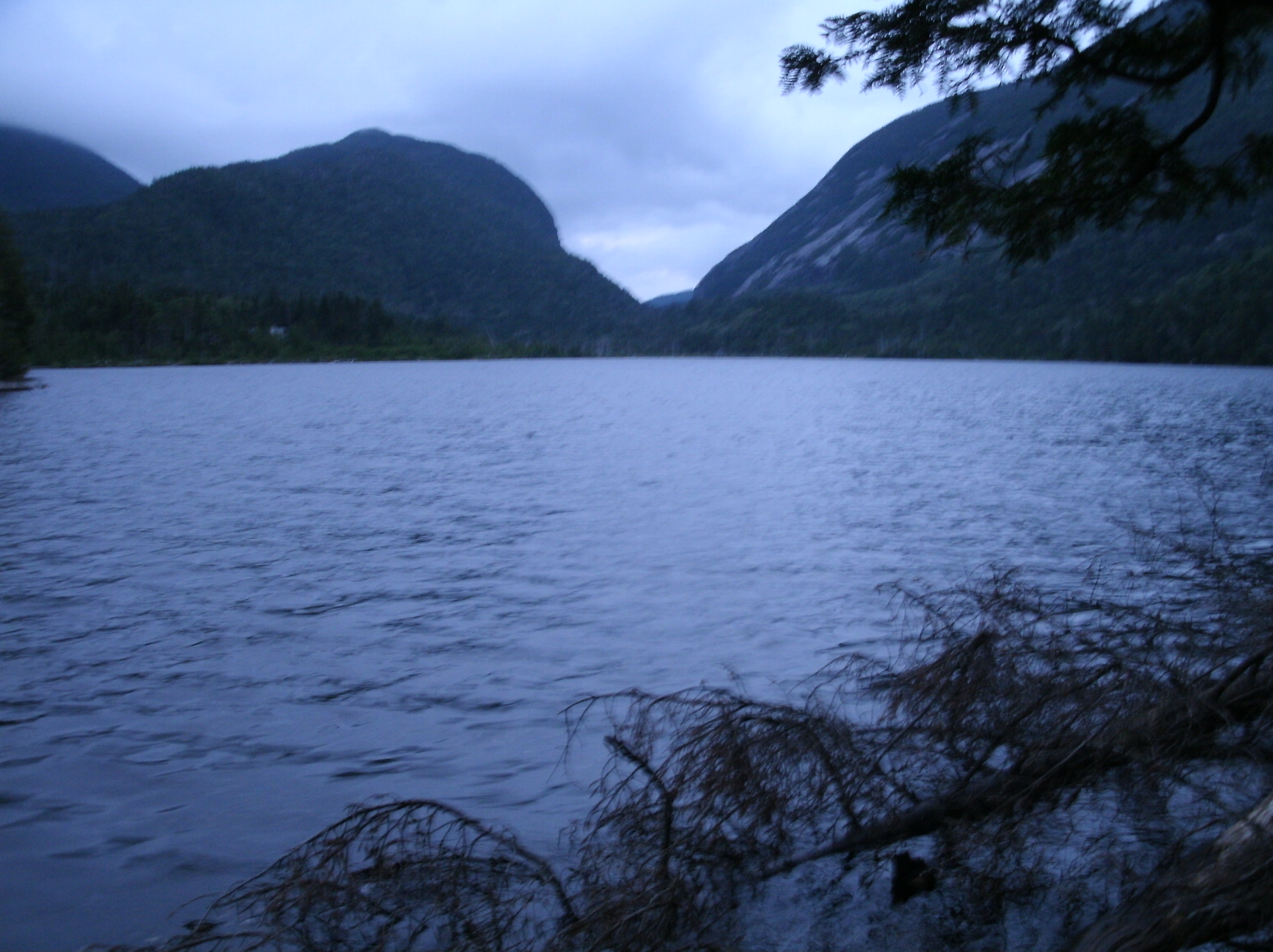
THE HARD WAY: Upper Works Trail from the parking lot. When the trail forks, go left onto Indian Creek Pass. Indian Creek Pass includes many exciting features, including lots of bear sign/scat, a peat bog area in the middle of the trail that will suck you in, giant toads, scenic river crossings, and water hazards. Expect to climb up rock falls and do a lot of elevation gaining. THIS TRAIL HAS A 10 FOOT LADDER. If you are leading a heavily packed goat take off the pack, carry it to the top of the ladder, then have the goat climb to the left of the ladder. If the ground is wet you won’t be able to get past this ladder as the rock face is almost too slippery in dry weather to get a goat up. If you have a dog, the dog won’t be able to get up at all. Next, take a right on Cold Brook Trail. THIS IS A HIGH PASS. You will be doing even more elevation gaining! Watch out for boggy areas, and keep to the river. As you crest the pass and begin down towards the lakes the trail will begin to wind and twist around the river. I personally lost it about a mile out from the campground and resorted to climbing down the river itself. When you finally get to the bottom of the valley you will be at a beautiful camping area around Lake Colden and Flowed Lands lakes. This is a popular camping location, so the lean-tos are likely to be taken. I personally recommend the area at the southern tip of Lake Colden, but suit yourself. Watch out for nude swimmers, drunk hikers, and wave at the 46ers who are worn out from summiting all day. Don’t plan on getting a lean-to. Bring a tent (or if warm, a hammock with bug shield). This is New York, so be prepared to share a communal fire, talk to people, and brush up on your knowledge of wines. Oh, and keep your goat(s) away from other camper’s toothbrushes. Remember to bring a tarp for the goat(s) if its going to rain.
If you are not familiar with loons, just remember there aren’t any wolves in the Adirondacks High Peaks region when the crying wakes you up at 5 am. Get breakfast, saddle up the goat, and take Algonquin Peak Trail to the southern end of Lake Colden. Continue on Calamity Brook Trail along the edge of the larger bodies of water, and eventually along the edge of “Flowed Lands”, AKA a large river/marsh like area. Somewhere in here is a short suspended bridge over the river. Wait for all hikers to cross it and then carefully lead one goat at a time across. It is an easy bridge, especially for inexperienced goats, to fall on or off if they spook and the river can be too high for them to swim or pack across. Look out for the funeral monument in this area. Otherwise, all of this will be relatively flat, easy, and enjoyable. Eventually you will hook back into Upper Works Trail and that will take you right back to the parking lot. Just make sure you don’t turn right back onto Indian Creek, (unless you want to have all this fun all over again! Hahahaha).
THE EASY WAY: Just take Upper Works Trail, STAY LEFT so you don’t take Indian Creek, and hike a pleasant flat stretch to Colden Lake. Snag a good camping spot and spend an enjoyable day exploring the lake side and doing some small side hikes. Hike back out the next day.
BE WARNED!
- For some reason, Adirondack trail maps seem to be rarely made with the actual GPS coordinates of the entire trail mapped out. Use them as a very loose guide of where you are going, the terrain, and the mileage you will be covering. Very very loose. You will feel at some point that the best use for the map instead of direction might be as a fire lighter, or perhaps even in the outhouse. But remember, the elevation may be wrong, the mileage inaccurate, and the actual location of the trail intersections totally misrepresented, but usually the lakes and the rivers are not entirely fictional.
- Watch out for bear sign. You are hiking with a hamburger on 4 legs. Even if your food is in a bear canister (hint: those are required to camp in the park) the goat is not! This is serious bear country!
- Watch out for boggy areas. If the goat won’t go, ask yourself why! I did not, being young and oh so stupid, ask myself why and spent twenty agonizing minutes standing on my toes up to my shoulders in a peat bog that sucked me in trying to figure out how to not die and get out with my shoes. Note that this peat bog was in the the middle of Indian Creek Trail. That’s right. You’ll walk right over it and get sucked in! Think of it as Hunger Games Adirondacks style.
- INSECTS! Oh, did I mention the INSECTS?! If you are going in the summer bring the DEET, Citronella, and possibly an atomic bomb. This place has deer flies, biting flies, midges, mosquito, and all of them are huge! If you go in the summer, be prepared!
- While not as true in High Peaks due to the large number of casual hikers, in many areas of New York if your party does not fill a lean-to you will be expected to share the lean-to with strangers until maximum capacity is reached. So bring friends, bring a tent, or be prepared to stay up late in the night as the lovebirds next to you in the lean-to sweet talk each other to sleep.
IN SUM: Does life bore you? Are you in need of excitement? Well we can do this the easy way or the hard way. It’s up to you.