Across the road from what is today the rather poorly reviewed Enota Retreat on Highway 108 is a fancy, but unnamed roadside spring. The land it sits on was once part of the YMCA Camp Pioneer, which was built in the 1940s and provided summer camp facilities for Atlanta children until 1986. While the old buildings (some apparently built by the CCC) have fallen to dust under the new management at Enota, the spring lives on, still running water out into a metal pipe with a small car pull over for anyone who wants to fill up.
Would I drink out of it? With a filter, yes. The water is running through a real spring head, with a real pipe, off forest land, and it’s located several foot off the ground. Should be a real winner if you like your spring water.
How you get there: It’s a pull over off highway 108, right across from the campground at about 34.840140,-83.773268, though my GPS was having trouble nailing it down I’ll admit.
Historic map showing Camp Pioneer and a structure that might be the spring circled in red.
In answer to the eternal question, yes, you can get up Brasstown Bald on an electric bike. It also turns out electric bikers don’t have to pay the $7 day use fee. I guess Cradle of Forestry figures you’ve earned it if you make it up there under (mostly) your own power.
The grade up is 16 to 24%, which you will notice. I highly recommend a 750 watt motor on this one, but normal people taking their time could do it on 500 watts, the super steep grade isn’t really that long and there are some almost straight aways. In addition, if you go by bike instead of car you actually get to enjoy the views from the road, a few small waterfalls, and one really awesome owl!
How you get there: There is a parking area at the start of the road up to Brasstown Bald for people to drop trailers or to access the trails. This is a superb place to park if you just want to ride up to Brasstown Bald (though it’s equally nice if you plan to ride 108, which is during the off season a scenic and low traffic road). Parking is located at: 34.848074, -83.798730.
Time for the ride: 4.8 miles out and back on a 16-24% grade with some straight aways that are significantly less. You’ll have to leave your bike in the parking area and walk the final mile to the top of Brasstown Bald on the paved trail – they don’t let you ride all the way to the top due to traffic issues. There is unfortunately no bike rack, but the park service guys were very okay with me chaining up to anything, including the front rails of the store since it was closed in the off season, which was really nice of them.
Best season to do this ride: As a popular tourist attraction I always suggest riding in winter on a week day to really enjoy your time going up, but Brasstown Bald is also a casual tourist destination – that means you can still ride in the summer, so long as you get up early before everyone else has rolled out of their glamping yurt and found their solar powered civet coffee maker in their ultra-urban trail bag.
Route to Ride
Yeah, you just start at the bottom at the sign and ride…up. There’s a few small waterfalls and a nice scenic overlook or two to stop and enjoy. Traffic does get excited on this road, so be prepared to ditch dive if necessary. When you get to the top the paved trail is behind the buildings to your right as you enter. If it’s busy and you don’t want your bike out in the open there are picnic tables on the far end of the parking area from where you entered – you can tie up to a tree over there. The paved trail is about a mile long with plenty of benches, and the old fire tower and visitor center at the top is definitely worth your time, especially since you get to visit for free! While the visitor center is closed in winter, due to Brasstown Bald’s height you can still climb the trail and play in the snow that remains on top of the mountain long after it’s melted down below. Either way, it’s worth the walk up.
The ride back down is the worst part of this trip – you will have to stop and cool your brakes a couple times – that burning smell is for real and I have it on good authority it happens to everyone biking this slope on an electric bike, probably due to the fact electric bikes are 2-3x heavier than non-electrics. Brake fade on a steep mountain road with drop offs, no guard rails, and a lot of traffic is a recipe for disaster. So stop and enjoy the view and save your expensive brake pads!
In sum: Electric biking is the only way you’re going to bike if you have a messed up knee. But that doesn’t mean it isn’t God Mode 🙂
Located just outside Kershaw, South Carolina, this preserve is very accurately named…for the exceptionally large rock face it contains. There’s also some semi-official foot trails, a water fall that occurs when it rains, and a big swamp that is referred to as a beaver pond. But I’m pretty sure it’s a swamp.
Is it goat approved? You could probably goat it. However, I did not have a goat on this trip.
How you get there: Google knows where this one is. However, if you want the coordinates, the upper parking area, which is the shortest route to the rock, is at 34.674922, -80.523634. There’s a lower parking area that’s much closer to the beaver pond/swamp located at 34.659202, -80.517052.
Parking lot at rock
Time for hike: Really, it’s all about walking out to the rock, which is about half a mile of easy flat gravel road away from the parking area. The rock itself is pretty huge (though more like 15 acres rather than 40).
Best season to do this hike: Fall and spring. The bugs were atrocious in summer and in winter you might have ice sheet on the rocks (well, maybe, this is the midlands in South Carolina). Go after a good rain.
Trails to Take
Start off in the parking lot, walk about 1/2 a mile down the gravel road behind the forest service gate and you’ll be at the rock. Pretty simple. There are numerous foot trails out here, most unofficial. The waterfall is only a waterfall if it has been raining recently, when I went it was a hot, dry August and none of the impression in the rock had pools and the waterfall was completely dried up. However, it feels somewhat mountainous because the plant life living on the rock is similar to what you find living on rock outcroppings up at higher elevations.
In sum: Pine dominated ecosystems always smell like car air fresheners to me.
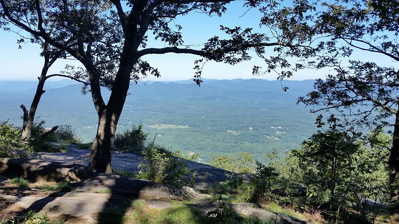
Yonah Mountain is a popular small park encompassing a single stony rise near Dahlonega, GA. The mountain stands by itself, visible from both the Appalachian Trail and distantly from the area of Dawsonville, providing an incredible view from the cliffs surrounding the summit. A good location for spotting Atlantans out for the weekend, and a great hike for dogs, enthusiastic kids, and less enthusiastic spouses, this basic but beautiful jaunt makes an awesome opening to this winter’s hiking season.
Is it goat approved? The trail is heavily used, but sparsely maintained or patrolled by the powers that be. I would not recommend a goat because of the traffic level, but it could probably be gotten away with here.
How you get there: Google “Yonah Mountain Parking Lot”. On the satellite image Yonah Mountain Road appears to travel up to the summit – but this road is gated and inaccessible. The actual parking lot is at 34°38’14.6″N 83°43’36.1″W off Chamber’s Road. Come early! The parking lot is large but heavily traffic. However, if 8 am isn’t going to work with your three year old, there is fairly steady turnover of cars and you can get a spot later in the day.
Parking is extensive, but it is not really extensive enough. Come early to get reasonable parking locations.
Time for hike: The distance for this hike is 4.4 miles round trip out and back. Expect a nearly relentless uphill the whole way to the summit.
Best season to do this hike: Year around. Wildflowers bloom throughout the summer, and primitive camping is allowed even on the summit throughout the year. However, be aware that the Army trains at the park, and the trail is closed on training days.
Trails to Take
The trail starts on the left hand side of the parking lot, about even with the pit toilets, (yes, that is the source of the strange smell you are going to be wondering about). It climbs first slowly through a lowland forest of unremarkable hardwoods. A short bridge crosses an unremarkable creek. Then, the trail comes up parallel to a steep incline, which develops into a wooded cliff. Boulders pop up, growing larger and larger, finally culminating into a rock scramble at one point.
Boulder scramble
Beyond the rock scrabble a field pops up out of the trees, leading to the first view of the hike, looking northwest. The trail continues on the far side of the field, growing steeper and showing signs of extensive erosion.
Wildflowers found on the trail
The trail comes up to a gravel road, turns right onto the road, and continues up to the Army training area. There are more pit toilets here. The trail splits at this point – if you want to go to the summit stay on the gravel trail to your left. This trail continues up a steady pace and begins to cross small rock faces. The number of wildflowers increases. The trail crosses a large rock face. At the far side of the rock face is another trail split. The right hand trail goes to a spectacular view at a primitive campsite. The left hand trail passes a small spring and continues, again at a steady climb, all the way up to the summit, which is around a quarter mile away at this point.
Trail side spring
Side trail at the rock face view
The summit itself is a bit of a let down for most people. The views are nonexistent, though side trails will take you out to the notoriously dangerous cliff faces where better, if stupidly dangerous views, exist. The main object of the summit is a large clearing surrounded by picturesquely stunted oak trees that pretty much screams “camp here”. Yeah, you can camp here. In fact, I plan to do so in the future.
Anyway, turn around and go back downhill to the car when you’re ready to go onto the more challenging stuff the winter hiking season has to offer!
Field at the summit of Mount Yonah
TRAIL MAP
Trail Map (courtesy of HikeTheSouth.com – my photo did not come out)
BE WARNED
Parking fills up fast in reasonable weather. Come early to get your pick of parking!
The US Army trains on the mountain, (they go rock climbing or something). When they are there you can’t be. Call 706-864-3367 to check on what days they are in residence.
Reminder that Yonah Mountain Road doesn’t actually get the public to Yonah Mountain. The real parking is off Chamber’s Road nearby.
The cliffs of this mountain have claimed many lives, including those of experienced hikers and backpackers. The views are not really good enough to die for, so stay back!
The US Army closes the park on training days.
In sum:
Always go the fun way. Life is too short to be boring.
Waterfalls aren’t really what you go to Cherokee for, but if you are interested in taking in a few the most reasonably nearby ones are Soco Falls between Cherokee and Maggie Valley on Hwy 19, Mingo Falls behind the Cherokee KOA, and The Deep Creek Trilogy of Indian Falls, Tom Branch Falls, and Juney Whank Falls. All these falls are FREE to visit, open pretty much all the time, and are family and kid friendly.
Is it goat approved? The Smokey Mountains National Forest guys aren’t too big into goats I can tell you from personal experience. However, the Deep Creek Trail is partially on a horse trail, and if you are there in the winter when the tourist traffic is much lower you could probably get away with it.
SOCO FALLS: A Kid’s Waterfall
Soco Falls
How you get there: 35.492680, -83.169191. The waterfalls is right off Hwy 19 between Cherokee and Maggie Valley. Parking is VERY limited and difficult because it is an unmarked heavily trafficked pull off on a bend in Hwy 19. All the warning you will get is one little sign about 0.5 miles from the pull off. This park is free and despite what it says online, there is no signage indicating that it ever closes.
Time for hike: There is a short and extremely vertical trail down to the falls. The trail itself is very worn as of my visit, making it exciting for kids, challenging for easily bored husbands, but probably not for your 90 year old grandmother or the arthritic 17 year old Labrador.
Best season to do this hike: Any time of year, but probably not in a heavy downpour as the trail is very steep.
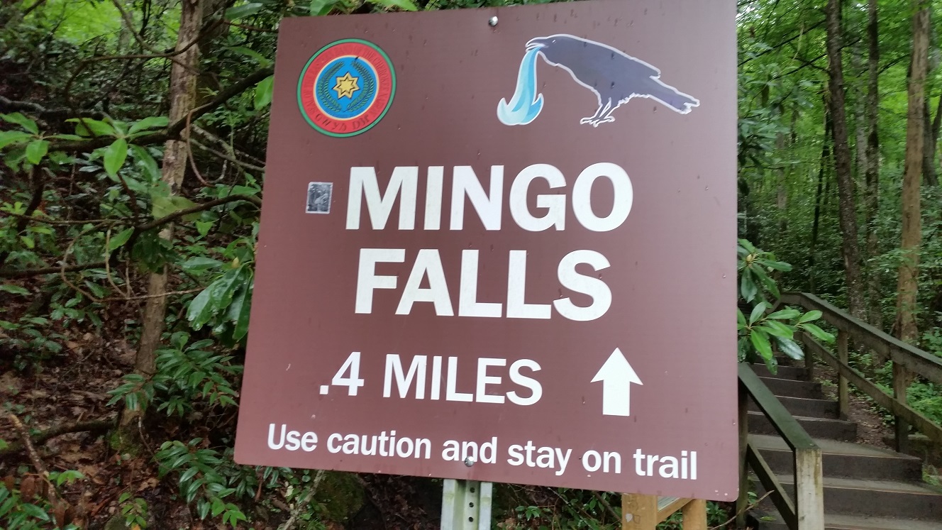
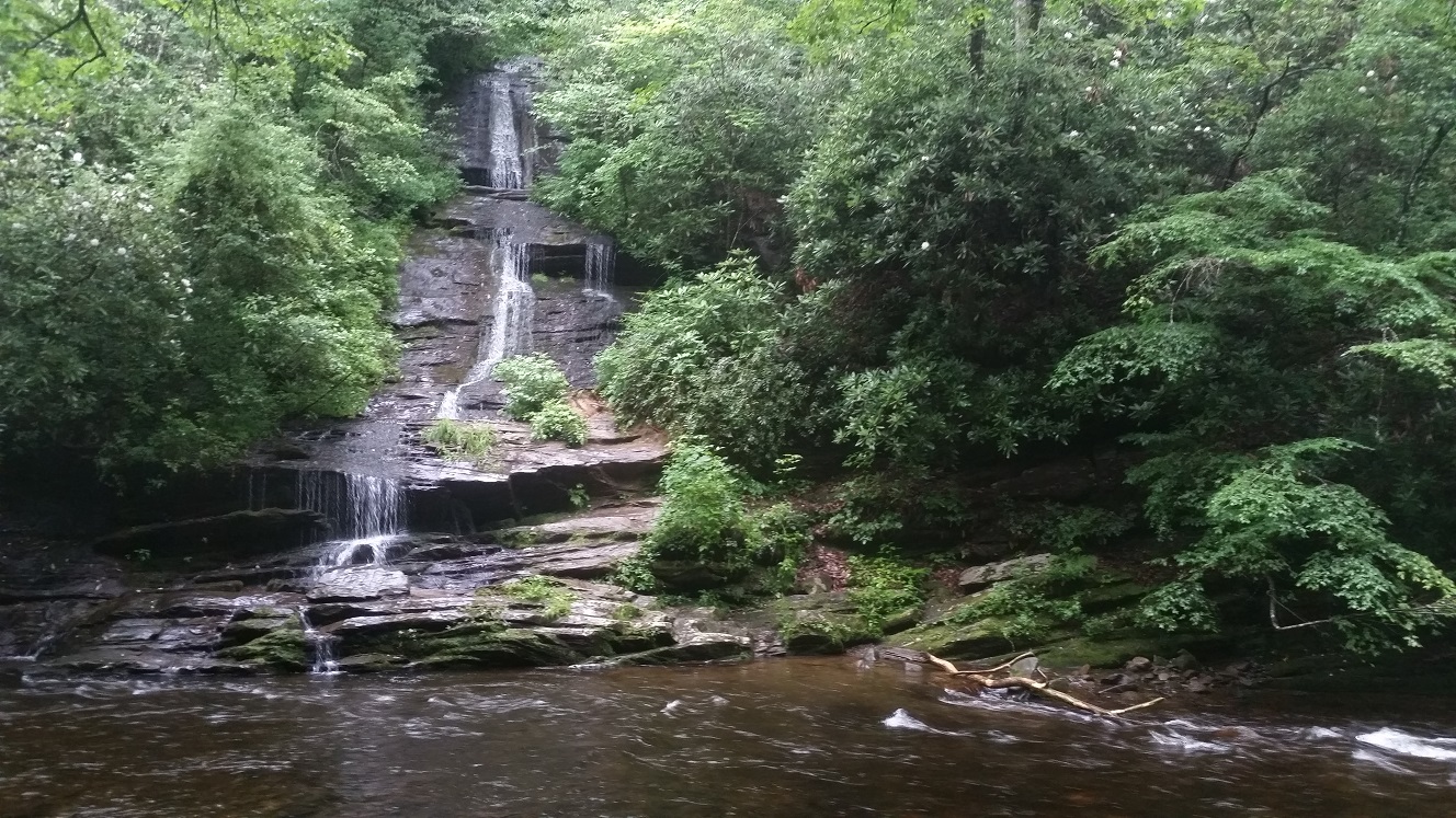
MINGO FALLS: The Falls of the Vomiting Bird
Mingo Falls
Chinese temple worthy stairs to the falls
Note vomiting bird. Think it has something to do with the creek name…
How you get there: 35.531855, -83.275751. The falls are right off Big Cove Rd, the epicenter of the commercial campgrounds in Cherokee. Literally, drive down Big Cove till you pass the KOA and then hang a right across the river and you are there. The parking area is small and for a tourist site the visitor level is moderate on week days. This park is free and has no signs indicating it ever closes.
Time for hike: About 15 minutes out and back. The trail is maybe 1/4 mile if that, though that section of stairs at the front is soul sucking if you slacked off all summer hiking and are out of shape. Like Buddhist temple search for enlightenment by climbing the stairway to heaven kind of sucking. This is a great trail for families being close to the campgrounds and a doable climb.
Best season to do this hike: Any time of year.
JUNEY WHANK FALLS: The Baby Falls of Deep Creek
The least impressive of the 3 waterfalls at Deep Creek, and the second most easily accessible, (Tom Branch is 1st), it is kind of like your own little put in your pocket and take it home kind of waterfall. Not too big. Not too small. But just about right.
How you get there: Google Deep Creek Trail Head in Deep Creek, NC. Now, there is a big campground and blah blah blah at this location. How you should get to this trail head is by taking Tom Branch Rd. This brings you in the back way – less traffic and less likely to be fees/etc associated with visiting. Tom Branch is gravel as you approach the trail head, but it is passable gravel even for your minivan with the dog and six kids loaded in the back. Just follow it in, cross the one lane bridge next to the campground, and the trail head is right in front of you. The parking area is small and based on the “drop off loop” I suspect during high season for tourists it is nigh impossible to park here if you arrive after 11 am. As an interesting side note – this is the one area I saw locals hiking. And speaking Cherokee, which was pretty cool!
Time for hike: The hike to visit all the falls is a loop of about 2.5 miles in total. Juney Whank has its own loop, but frankly Tom Branch and Indian Creek are more impressive, and the trail is very easy…so just do them all. Start on Deep Creek Trail, (this trail head is to one side of the parking lot), and follow this mostly flat trail out to Tom Branch Falls, then up a slight incline along the river to Indian Creek Falls, and finally about a mile on increasing but not crazy incline to Juney Whank. Then its down hill to the parking lot.
Best season to do this hike: Any time of year.
TOM BRANCH: Deep Creek’s Place of Meditation
Tom Branch Falls is actually across the river from the trail and has its own seating area and spot to go down and play in the river. A good area to let the kids cool off or to relax and enjoy the sound of the water.
How you get there: Google Deep Creek Trail Head in Deep Creek, NC. Now, there is a big campground and blah blah blah at this location. How you should get to this trail head is by taking Tom Branch Rd. This brings you in the back way – less traffic and less likely to be fees/etc associated with visiting. Tom Branch is gravel as you approach the trail head, but it is passable gravel even for your minivan with the dog and six kids loaded in the back. Just follow it in, cross the one lane bridge next to the campground, and the trail head is right in front of you. The parking area is small and based on the “drop off loop” I suspect during high season for tourists it is nigh impossible to park here if you arrive after 11 am. As an interesting side note – this is the one area I saw locals hiking. And speaking Cherokee, which was pretty cool!
Time for hike: The hike to visit all the falls is a loop of about 2.5 miles in total. Juney Whank has its own loop, but frankly Tom Branch and Indian Creek are more impressive, and the trail is very easy…so just do them all. Start on Deep Creek Trail, (this trail head is to one side of the parking lot), and follow this mostly flat trail out to Tom Branch Falls, then up a slight incline along the river to Indian Creek Falls, and finally about a mile on increasing but not crazy incline to Juney Whank. Then its down hill to the parking lot.
Best season to do this hike: Any time of year.
INDIAN CREEK: The Generic Waterfall of Deep Creek
My husband described this as the most boring waterfall on the loop for photography. It is big, has plenty of water after a rain, and is, okay, yes, a waterfall. But beyond that…nothing too exciting. Unless your husband does crane stance when he doesn’t realize you have the camera out.
How you get there: Google Deep Creek Trail Head in Deep Creek, NC. Now, there is a big campground and blah blah blah at this location. How you should get to this trail head is by taking Tom Branch Rd. This brings you in the back way – less traffic and less likely to be fees/etc associated with visiting. Tom Branch is gravel as you approach the trail head, but it is passable gravel even for your minivan with the dog and six kids loaded in the back. Just follow it in, cross the one lane bridge next to the campground, and the trail head is right in front of you. The parking area is small and based on the “drop off loop” I suspect during high season for tourists it is nigh impossible to park here if you arrive after 11 am. As an interesting side note – this is the one area I saw locals hiking. And speaking Cherokee, which was pretty cool!
Time for hike: The hike to visit all the falls is a loop of about 2.5 miles in total. Juney Whank has its own loop, but frankly Tom Branch and Indian Creek are more impressive, and the trail is very easy…so just do them all. Start on Deep Creek Trail, (this trail head is to one side of the parking lot), and follow this mostly flat trail out to Tom Branch Falls, then up a slight incline along the river to Indian Creek Falls, and finally about a mile on increasing but not crazy incline to Juney Whank. Then its down hill to the parking lot.
Best season to do this hike: Any time of year.
In sum:
If you wanted to get your hike on but you brought the kids, the dogs, the grandparents, and all the women who would rather go shopping, these are the waterfalls you can actually get them to go to before everyone goes out to shop for moccasins.
You think you’re tough? You think you’ve acclimated to the sauna-esque climate of the Deep South? Test that belief by taking a little hike during midsummer at Fant’s Grove, South Carolina’s most well known experimental forest.
Originally marginal farm land, the forest known as Fant’s Grove is now the Experimental Forest for Clemson University. Along with several research farms nestled among the pines and oaks the forest itself also acts as an outdoor lab for forestry and ecology work. For those into history a number of ruins are present in the forest, some of which are visited on this trip. The only real snag is the overwhelming southern heat and humidity, which will get you even if the yellow jackets don’t.
Is it goat approved? Dunno. They do everything else, so as long as you don’t go play with the cows and sheep with a goat in tow, they probably won’t care. The horse back riders in the forest are generally the really serious trail riders, and their horses find a goat amusing rather than terrifying.
How you get there: Google “Fant’s Grove Trail Map” which has a grey box with GPS coordinates for the parking areas on it.
Time for hike: The distance for this hike is around 8.5 miles round trip, including the out and back to the point on the lake.
Best season to do this hike: Winter or cooler weather. You want to avoid the yellow jackets, and the sweltering summer humidity unless you’re a South Carolina native who is used to putting up with it. During the school year it is also a popular location for students/classes and this will increase the traffic while clogging the parking areas with forestry student pickups. You can identify these by the number of bucks and ducks unlimited stickers on the windows, as well as a preponderance of camo, which is considered a primary color akin to red, blue, and yellow in the south.
Trails to Take
I went with the red and grey trails, which make a loop from the parking lot just before the church, (Fant’s Grove Road Trailhead), down to Big Oaks Parking Lot and back. The route is something like B6 -> B7 -> B9 -> B10 -> B11 -> B12 -> B24 ->B25 -> B27. The “B” numbers are posted on standard metal park service trail markers, but be prepared to find numbers that aren’t on the map. However, the numbers go in order, so if you find a B26, odds are if you walk past it you will eventually find B27. In general though, expect to be lost, (see BEWARE section). Every one who hasn’t ridden there for thirty years gets lost, that’s part of the fun. They even have an orienteering challenge that is hosted in the forest each year cause everyone gets turned around.
Trail marker with number
The trail heads out from the parking lot, which is a pull in area for horse trailers and a smaller pull in up top for cars/trucks. If you are parking down in the pull through, park hard on the side of the road so that horse trailers can pass without taking out your rear view mirrors.
Old pump house that once fed water to the research areas from natural springs
When you leave the parking area you want to head to your left. There will be up to 3 trails presented to you that all look to be blazed red. Take the left most. You will know you have the right one if you pass an old pump house. This takes you past the church, then across the road. Be careful crossing the road because cars go about 60 mph down through here. When you cross the road, almost immediately, you will see a historical sign for the old school house. The ruins are scattered among the bamboo grove. Further down hill about twenty feet off trail to your left is a sign indicating the original spring that provided water for the school.
School house ruins amid bamboo in Fant’s Grove
Spring that students hauled water uphill from at school house
Cherry inspecting the school house steps
The trail winds out through the woods, eventually dumping you out on Rocky Ford Road. You can go left to continue on the red loop, or go right to go down the road. About 1.5 miles from the trail intersection Rocky Ford Road will leave you on a point of land jutting out into the lake. If you walk down to the lakeshore, you will be looking right across at one of Google’s little jokes – the Redneck Yacht Club Cove.
The neck of the point is also a great place to stop and water goats or play in the water. There are several cut offs of the main part of Rock Ford Road, but the one you want to get down to the neck/cove is the 3rd cut off, which goes very sharply to your left and slightly down hill, while the main road becomes overgrown with lespediza.
Cherry walks on the bottom of Lake Hartwell, which for most of its history has been at least 15 feet below full pond since Atlanta keeps draining the south dry of water like a giant straw pointing to the west. Though since the drought cycle is 11 years of good weather and 11 years of desertification, it does refill occasionally.
The Rocky Ford Road is an out and back, after which you continue on the red trail, which eventually joins up with the blue trail just before dumping you in the Big Oaks Trailhead parking lot. During the school year when classes are being held this parking lot is usually packed with forestry majors out for classes – which is why I recommend parking up at the Fant’s Grove Trailhead or elsewhere.
Big Oaks Parking – too small for horse trailers, but popular with students and bikers
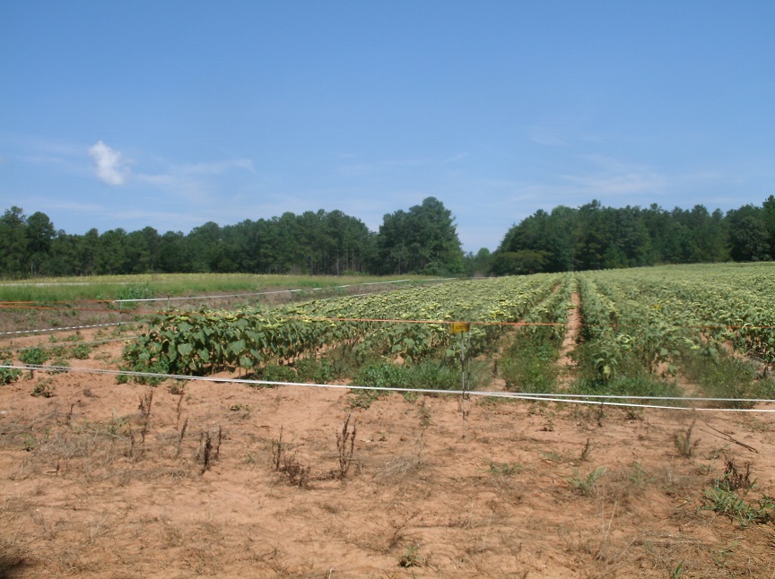
To continue, cross the road and walk along the edge of the experimental agricultural plots. Walk along the backside of the plots, and then the trail goes into the woods. At this point it is blazed yellow – the purpose and position of the yellow trail is anyone’s guess, like most of Fant’s Grove. You’ll see those yellow blazes pop up occasionally. The red trail will cross right across the yellow trail and you want to go left once you find it.
Experimental plots planted in sunflowers
At the next intersection, go right, (yellow blaze is to your left and a small red arrow does point right to help you figure it out). Then follow the trail back to where you left the truck and you’re done.
High water flood mark for Lake Hartwell – tells how far up the bank the Army Corps of Engineers can raise the lake
Only box turtle I’ve ever seen in Clemson
Toad
BE WARNED
Be prepared to be lost. No complete map of Fant’s Grove’s many trails, roads, and bush hogged cuts exists. Bring a compass or a friend with a good sense of direction.Ask anyone who looks like a cowboy out of a 1970s western sitcom for directions. They’ve probably been riding the place for years and will know what’s what.
Don’t park at the Big Oaks Parking area during a week day when Clemson is in session. Students may block you in when out for labs.
Leave space when parking for horse trailers to pass if you are at the Fant’s Grove Road Trailhead parking area. Alternatively, park in the uphill smaller lot with the ropes that is more meant for hikers.
Be careful crossing the road…I used to drive like a maniac through the forest, and I’m not too surprised everyone else still does.
Dove season means open season on shotgun shells in the experimental agricultural plots. Prepare not to be dead if you go during this period. Ditto for deer season.
If you happen to pass the Swine Center and see a sprinkler running DO NOT go play in it! This is the overflow for the lagoon, (for those of a non agriculture persuasion a lagoon is a pond where they sediment out manure, similar to a human sewer system sedimentation system). Which means you aren’t dancing in the rain, you’re dancing in *&!^@.
Watch for yellow jackets. And horses running away from them. This forest is bad for the little yellow menaces.
Agricultural and experimental plots are present in the forest. Goat grazing may delay thesis and dissertation completion! Be kind to suffering graduate students!
In sum: The best moments of your life happen in college, (well, undergrad anyway). The least best moments happen at 1 pm in 100% humidity when you’re running from yellow jackets in the Clemson Experimental Forest.
It is surprisingly refreshing to come upon a park devoted solely to horseback riders. Like mountain bikers, the riders of four legged beasts enjoy going fast, and generally don’t get the opportunity to do so because a 1000lb behemoth rocketing down the trail at 40mph tends to have trouble stopping quickly when the random family with the baby stroller pops out of the shrubbery unexpectedly.
An added perk to this wonderfully horse and hiker only slice of heaven is I have it from the mouth of a Cherokee County park service guy that goats may use the trails, provided they are on leash, and don’t commit suicide by freezing in the middle of the trail when a horse comes around the corner at a gallop
Is it goat approved? Yes. Per the park service guys and one member of the Garland Mountain trail maintenance group. However, it is a park devoted to horseback riders which is maintained by a volunteer force of horseback riders, so horses ought to come first.
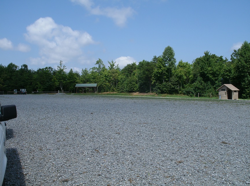
How you get there: You want to go down Highway 140. Just after you pass through Waleska, GA, (a nice spot to grab a sandwich) it’s a few miles further on. You’ll see the brown and white sign for it just before Garland Mountain Road which is not surprisingly the road you want.
Massive parking lot! This place is SO EASY TO PARK AT! It’s great! Also has a restroom as seen on the right.
Time for hike: The distance for this hike is around 4 miles round trip, using the orange, yellow, and green trails
Best season to do this hike: It wasn’t too buggy in the summer, but I would avoid the weekend during nice weather for horseback riding as this place is super popular.
Trails to Take
Start off at the parking lot. To the right of the trail kiosk is the trail you want. Its an orange and yellow blaze. Take a good look at the trail signage – it’s indicated with horse shoes pointing in the appropriate direction. It takes a minute to make sense.
Trails are easy, flat, and well maintained thanks to the local horse clubs
Follow the orange trail (Sorrel) down, crossing over some small intermittent streams and past a nice picnic area with lots of horse tie outs. Then go up a short hill and you’re on the green trail, the “Garland Greenway”. This trail feels like an old road or rail line and is wider with more grading. Follow that up until you reach a pair of gates blocking further forward movement. The yellow trail comes into your left, and you can get back on that to go back around.
One of the several well maintained picnic areas in the park
All in all, the park is well maintained, with good signage and only a few random side access trails made by users in search of a short cut. It goes mostly through hardwoods, with a preponderance of nut trees, which seem to be common in the northwestern part of Georgia. Elevation gain exists, but since the trails are designed for horses they run parallel to the hillside and their are no grueling climbs, just nice easy up and down swoops suitable for a prolonged gallop. Good little short trip for those days when you really want to be lazy.
One of the horse playground obstacles
BE WARNED
This is a horseback riding and hiking ONLY park. This means that goats will encounter horses that are not familiar with goats. You may spend a lot of time standing off trail allowing spooky horses to pass. If your patience and politeness is insufficient for the job, go on a week day and if possible during very hot or very cold weather – the park is practically deserted.
Note that bikes and trail runners are not welcome at this park – an important distinction if you enjoy these other hobbies and are tempted, (as I have been), to do something that maybe should be done elsewhere.
There is mountain laurel in places in this park. Mountain laurel is poisonous to goats. Avoid the green vomit of doom by making sure the horned minions don’t partake of a lot of it.
Park your car/truck/trailer by backing in. When dealing with parking lots used by horse trailers you want to make it as easy to get out as possible or a 7 horse slant load featherlite may accidentally block you in.
If horses are a new species to you, keep the goat(s) and yourself as far away from them as possible. Horses that are frightened by these strange horned demons on four legs will kick, rear, or bolt, and may inadvertently clobber you dead in their attempts to get away from you and your animals.
The trails here are short, so consider this as an easy day out or an after work dalliance, rather than planning a whole day. There are lots of great picnic areas with horse/goat tie ups. Lunch may be advised.
There is a “horse playground” which has a number of training obstacles that may be fun to try with a goat so long as no horses are using it.
Watch out for unauthorized ATV riders going 900 miles per hour down the trail. Goat versus bush guard doesn’t end well for the goat.
In sum: Life in the mountains goes at a slower pace. Especially on a nice, empty stretch of trail.
There are trails for which there are no maps. You find out about them from word of mouth, or possibly just by stalking someone who looks like a local when they dive down what appears to be a game trail and turns out to be a path of such spectacular spender that you begin to feel that you might have accidentally fallen through a wardrobe to an impossible fairyland. Their names, when they have them, invariably are far less amazing than the places they go and are generally based on the local topography, (“Gorge Trail”), what road they’re on, (“Guion Farms Trail”), or for the most literally minded, how hiking them makes you feel after a while, (“Dismal Trail”). Welcome to the wonderful world of the undefined and exploration rich hike that is traversing “social trails”.
Location: The area northeast of the South Hill Recreation Way, which encompasses the old drinking water reservoir and water pipes, the current drinking water reservoir, the Wildflower Preserve, several dams, the unofficial nudist beach, and an absolute maze of old and new social trails.
Is it goat approved? Yes. These trails are “social trails” so there are no hard and fast rules. However, accessing this area through the Wildflower Preserve or South Hill Recreation Way will require the goat to be on leash, (in theory). Off these official trails I would almost recommend keeping the goat off leash, since sections of the route are really more like walking through the woods than on trail, with the concomitant issues of tree climbing and general silliness.
How you get there: You can enter this maze from several directions, but the easiest is probably to start by parking off Burns Road, near the intersection with Coddington Road in Ithaca, NY. Look for the gravel pull over and the trail head for the South Hill Recreation way.
Time for hike: Something between 1 hour and most of the day depending on how much exploration you are interested in doing.
Best season to do this hike: All year, but buggy in summer.
Trails to Take
*Solid red lines on the associated maps indicate clearly defined trails. Dotted lines indicate poorly defined trails, general directions to hike, and trail areas that are subject to shifting a lot*
Start off at the trail head off Burns Road. Walk down the gravel road that is the South Hill Recreation Way. You will pass a historical marker discussing how this trail used to be a rail line.
A ways down the trail, a patch of pine woods will come up on your right. Start looking for unmarked social trails going off into the woods. The last time I was out here the trails going off the Rec Way in the vicinity of this patch of pines were the shortest route to get down the reservoir. Things may have changed. Continue down into the woods, trying to keep north to northwest on any social trails you encounter, but always heading away from the Rec Way. Avoid taking trails that pass by the “water reservoir – no trespassing” signs as this will take you too close for comfort to the current drinking supply. Eventually you should hit upon a well defined trail going off to your leftish/northwestish along the ridge above the water reservoir. If you miss this turning you’ll end up in a maze of trails that makes a loop on the south side of the reservoir before sending you back to the Rec Way.
Assuming you find the ridge, continue until you reach the reservoir dam and the outflow of the river. Then turn left off trail, and climb down the steep slope along the edge of the gorge. This is a bad area for loose rock – avoid the easy route of climbing right along the very edge of the gorge! Don’t hike with the goat on leash here, since you want it to die of its stupidity without taking you with it.
At the bottom of the hill there is a section of river with large stones that is popular for swimming and sunbathing. Stay on your side of the river and continue along the river edge following a poorly defined trail. You will pass through an area of mud and small springs/streams.
What counts as a “more defined trail”
The trail will become more defined, eventually leading down to a ledge of rock that you walk along and a very rocky area of the river. This, I have been told, is the unofficial nudist beach for Ithaca. Beyond the nudist beach is the pond/old Ithaca water reservoir. The trail climbs up hill, stopping at a picturesque clearing with a good view of the pond. Across the pond is a large field.
Continue along the edge of the pond on a mostly overgrown trail with excellent goat forage but also lots of snakes. Eventually you will reach the pond dam, a popular swimming location, and the cliffs above it are popular diving locations for the local youth/hooligans. There is the remains of a water control building, and old water pipes are visible across the river. Continue along the edge of the river, passing by a second dam along with an excellent fishing hole just below it.
Old Stairs in the Woods
The trail will become much more defined and begin to feel “old”, (that is, like it was intentionally built). Ruins of walls and in one area, a quite nice set of stairs, will be passed. Look for trails heading up hill from the stairs, and follow these into another maze of social trails, eventually culminating in reaching the South Hill Recreation Trail again. Walk down the trail, or parallel to it on a social trail, until the hill becomes very steep, with the river in a small flat flood plane below it. As you near the end of the Rec Way a gravel road in varying states of disrepair comes off the trail and goes down the hill. This, or a social trail near it, leads more or less to the small water treatment plant along the river. Find a way down to this water treatment plant, (it sits right on Giles Street).
What the trail looks like when it is “poorly defined”
Walk around the treatment plant, and directly across Giles Street from it is a gravel road that is usually barricade by a gate or rope or something. Cross the street, go around said barricade, and continue down a really really steep gravel road. The road goes around a hill, and drops you off at the river. Across the river, in the cliff faces, is some amazing old ruins dating from when the old reservoir was still in use, (apparently a different piping system is now used for Ithaca’s water). Then, turn around and head back, or across Giles Street bridge and explore the opposite side of the river!
Be Warned!
This hike takes you near the CURRENT DRINKING WATER RESERVOIR FOR ITHACA. For those not up on basic public health, taking an animal, (or human), and letting it defecate near the place where your drinking water comes from is not a great idea. A fascinating example of prior mistakes in this area in Ithaca is the major 1903 Typhoid epidemic which killed hundreds, including Cornell University students, when the local water supply was contaminated with typhoid due to poor sanitation and possibly by asymptomatic typhoid carriers working for the water company. Needless to say this water company went bankrupt in the ensuing death and carnage, but the remains of this system’s piping can still be seen in the area. Ithaca still derives its water from the same dammed river that started the epidemic. Those who forget history are doomed to repeat it. Possibly with the assistance of a goat. So keep your distance!
These are social trails. This means that they are defined by social consensus, and as a result, that these trails may change in their location and where they lead over time. Be prepared to find my rough map is very nearly entirely inaccurate, not because I have it in for you, but because a bunch of other people, I guess, have it in for you!
This hike leads along the edge of extremely unstable gorge cliffs composed of rock that has a bad habit of randomly falling to pieces under your feet or in your hands. Remember that only you can prevent your own embarrassing and excruciating demise. Stay away from the edge, don’t attempt to climb, and don’t follow the stupid goat who wants to do any of the above.
This trail will require climbing “strenuous” hillsides.
Watch out for snakes around the ponds.
If you are easily embarrassed, watch out for nudists on the river.
Be prepared for lots of off leash and out of control dogs.
Be prepared for hippies, spiritualists, New Age shaman wannabes, and adults building club houses of out of tree branches and vines. This is Ithaca after all.
There is a woman who walks the recreation trail that is deathly afraid of goats.
There are tons of little creeks crossing the hike that Google appears to be ignorant of. Be prepared to get wet and muddy!
In Sum: The greatest secrets are the ones you discover for yourself, [or insert another boring fortune cookie-esque platitude of your choice here]