
I decided to be crazy and try to bike the entire Blue Ridge Parkway on the electric grocery getter. It seemed like a cool idea until I realized with 3 batteries at 650 watts a battery…I managed about 28 miles because you know, you’re like climbing mountains and stuff. So I’ve broken this particular pointless project into stages. This is stage one, which is the start of the Blue Ridge Parkway in Cherokee to as far as I could get before the little blinking light on the bike said I needed to turn around if I didn’t want to walk back. I look forward to future stages were I’m in better shape or not climbing up from a valley and the mileage gets a tad bigger!
In fairness to the ride, the highlight of this one is probably the elk in Cherokee, which, when you spend 8 hours or so riding, you can see when they punctually arrive to that big field at the Oconaluftee Visitor Center every night in the summer at 7pm. Being elk though they have a tendency to hang out in the road and stop traffic and let me tell you biking past one is not exactly a comforting feeling. These animals are taller than a horse and the horns put a whitetail to shame. Also, if you approach within 50 feet you can (and will) be fined by the appropriate protective park rangers who shepherd them across the road.
Other than giant herbivores the route includes a host of wildflowers including rhododendron, solomons seal, native azalea, and fire flowers among others, all of which are very easy to photograph from a bike seat in comparison to a car. There are numerous overlooks and tunnels, and also a really nice visitor center at the Browning Knob Overlook, which is high enough up you’ll get some basalms and the big rhododendrons in that area.
So in general a nice ride with a payoff in giant herbivores at the end of the day. Not a bad start to the Blue Ridge Parkway.
How you get there: I parked at the Oconaluftee Visitors Center. Historically this has been free parking, but starting in 2023 they charge $5 a day or $15 a week to park in their parking area. The parking area is very safe, and there’s a self serve kiosk to get your parking pass, so if you have the cash, park here. If you don’t want to spend the cash you can park at the pull off for the river just at the turn onto the parkway, on a pull off near the parkway sign, or if you want to be a little more considerate of your fellow man at the first overlook up the parkway. You won’t be missing anything by parking there – the climb out of Cherokee is pretty mundane and the first several overlooks are not impressive at all (or overgrown).
Time for the ride: As previously advertised, I made it 28 miles, then I had to come back, so 56 miles total. The way in is up hill except for 2 short and one very long downhill. The way back is up that long downhill, and then probably 75% downhill back to Cherokee, to the point I got tired and exhausted handling the bike around curves at 35 mph for miles on end and stopped and actually took a break. From going downhill. Your mileage may vary!
Best season to do this ride: In June when I started the ride it was 49F in Cherokee. Which is the valley. It’s the frigging mountains and those basalms are Canada trees. Stick to the summer if at all possible. The parkway is also closed and over-snowed during certain parts of the year.
Route to Ride
Starting at the Oconoluftee Visitor Center you hang a left out of the drive headed back towards Cherokee. The next turn on your left is the Blue Ridge Parkway, about a mile from the parking lot. There’s an only mildly defaced sign marking the entrance, but surprisingly nothing spectacular for the start of what is generally considered a well known scenic road (though less cared for now than it once was).
The road begins its ascent and it’s going to keep on ascending for quite a while because you’re coming out of the valley Cherokee lies within. The first several overlooks are nothing spectacular, especially if you’re used to the mountains. These include Raven Fork, Ballhoot Scar, and the Oconoluftee Overlooks, which are somewhat overgrown and not exciting. Wildflowers on the side of the road add some interest until you reach your first tunnel, where in you should definitely turn on your lights. If you’ve driven the parkway before and cut corners on the light thing because hey, most of these tunnels are all of 5 seconds long, they’re a hell of a lot longer (and darker) on a bike. Bring a real bike light you can ride in the pitch black with and a real, bright, and preferably pulsating rear light. You want to be visible in that dark to cars. Now you may be asking “Is there a bike lane in the tunnels on the Blue Ridge Parkway?”. The answer to that is actually yes – there’s an edge inside the tunnel about the size of a standard bike lane. While the rest of the road has no bike lane or shoulder to speak of and can be slightly terrifying, at least in the tunnels there is a way to get out of the path of an oncoming car pretty readily.
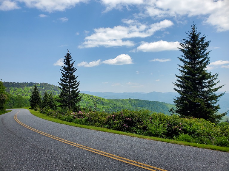
There’s a series of tunnels and overlooks from here (ala classic Blue Ridge Parkway), and now the overlooks are starting to be worth stopping at. The highlights include (in order of approach): Rattlesnake Mountain Tunnel, Thomas Divide Overlook, Big Witch Overlook, Big Witch Tunnel, Bunches Bald Overlook, Bunches Bald Tunnel, Qualla Indian Reservation Overlook (see interpretive signage here for the Cherokee Reservation), Lickstone Ridge Tunnel, Plott Basalm Overlook (see interpretive signage here for the origin of the Plott Hound, a famous bear hound developed in the valley below the overlook), Soco Gap Overlook (no view/overgrown), and as you pass along the road look out for the bright blue and precariously perched fire tower sitting on a ridgeline off in the distance. So glad I don’t have to go up that for work. At this point you’re firmly in the realm of the spruces and basalms, but you won’t be for long, so enjoy it.
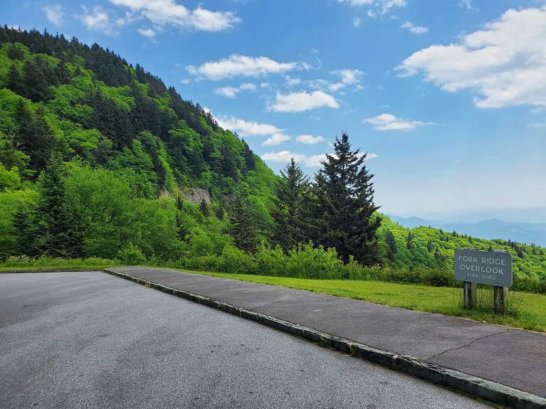
Then you’re headed past Thunderstruck Ridge Overlook, Hornbuckle Valley Overlook, and finally the turn up to Browning Knob and the visitor center, which sells a variety of hydration and the best Blue Ridge Parkway patch I have thus far found to stick on the panniers. The views up at the Visitor Center are worth the short detour up to it. Then back down for Yellow Face and Fork Ridge Overlooks back on the parkway. This is followed by more overlooks, (Scott Creek, Wesner Bald, Woodfin Cascades, Woodfin Valley, Mt. Lynn Lowry) and then finally you drop into a quasi valley and cross over Hwy 74.
The last leg of this stage has you climbing again, though the woods aren’t super exciting (it’s a lot like coming out of Cherokee at the start). Standing Rock Overlook though is worth a stop – it’s named after the large rock standing (hahaha) right next to the parking area. Generations of children have tunneled under it, creating a playground out of the boulder. It also reminds me of the rock that when I was like 5 years old we stopped and peed behind in a downpour on the parkway. Perhaps it’s the same rock, though obviously the ammonia smell has dissipated with the 30 year time lapse. As a convenient turn around, make a loop around the parking lot, and then ride back!

Elk on the road in Cherokee – yes I literally rode past it a few seconds earlier on the shoulder (mostly because I didn’t see it till I was level with it and went “oh shit what hell is that”)

Farm museum at the Oconaluftee Visitors Center

Sign at the start of the parkway

Native azaleas on the parkway
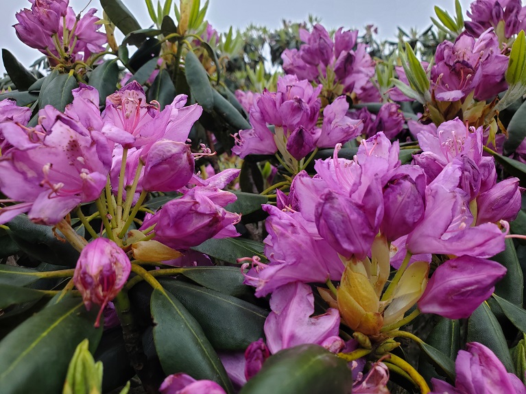
Rhododendron on the parkway

Tunnel on the parkway

What being inside the tunnel on a bike is really like – horrible visibility and dark!

The Plott Hound sign at the overlook talking about the creation of the Plott Hound hunting dog
One of the overlooks

The scary tall fire tower thing
Riding among the spruce

The standing rock at Standing Rock Overlook
In sum: If you were expecting me to make a map of a well known car road you can google just like zat and stick it on this blog post… you’ve got too high of an opinion of my work ethic.
