
If you survived high school after the 80s and hung out with the art kids, you have probably seen a really strange movie called “The Labyrinth”. This movie, for those not so unfortunate as to have set through it, includes David Bowie of all people as a goblin ruler dancing around in skin tight pants and 80s hair while the movie flashes back and forth between his surreal dance scenes and a teenage girl running through a giant, ugly maze populated by bizarre puppets. What can I say. It was the 80s.
The only real connection between this dreadful movie and Panthertown is that you will begin to feel like you got transported to an impossible labyrinth populated with random campers by some malignant forest spirit if you don’t bring a map for this one.
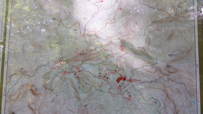
I personally recommend the map “A Guide’s Guide to Panthertown, Bonas Defeat & Big Pisgah” for this trip as it shows both social and forest service trails, and you will need social trails to reach most of these waterfalls. However, the recommended map does NOT include the blaze colors for the forest service official trails. You can pick one up at the Mast General Store in Hendersonville, NC.


Is it goat approved? Panthertown lies in the Natahala NATIONAL Forest Ranger district. Unlike state forests national forests do not require permits in North Carolina to bring single pack goats onto the property, (I did actually contact them to check). In later posts I will be up here again doing different trails with a four legged minion in tow!
How you get there: Google Cold Mountain Gap Trailhead. This is near Lake Toxaway. Follow google! But ignore it’s directions when you are on Cold Mountain Road…it doesn’t seem to know exactly where you are when you are driving that one.
Time for hike: The distance for this hike is only around 3 miles. It is mostly out and back with LOTS of social trails, bushwhacking, and orienteering opportunities. This means it will take a lot longer than 3 miles usually does.
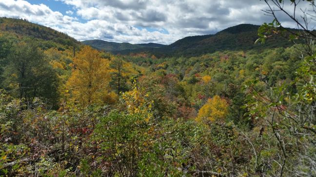
Best season to do this hike: Autumn is gorgeous. Summer can be kind of muggy and unpleasant. Winter is a viable option. Spring will net you some nice rhododendron blooms. In terms of traffic, summer and autumn are the most heavily trafficked, but on this route you can be guaranteed of meeting few people anyway since it utilizes a lot of off main trail pieces.
Trails to Take
The easiest way to get started on this waterfall rich hike is to walk straight down the gravel entrance road, and directly forward on Mac’s Gap Trail. You know you are on the right trail if not three seconds after passing off the gravel you are walking in a powerline cut and the trail runs directly beneath a tower holding up the powerlines. Continue on this trail looking for a side trail that may or may not be marked with pink ribbon that leads off through the mountain laurel. If the trail runs beside the river you’ve gone a bit too far – go back up hill and keep your eyes peeled.
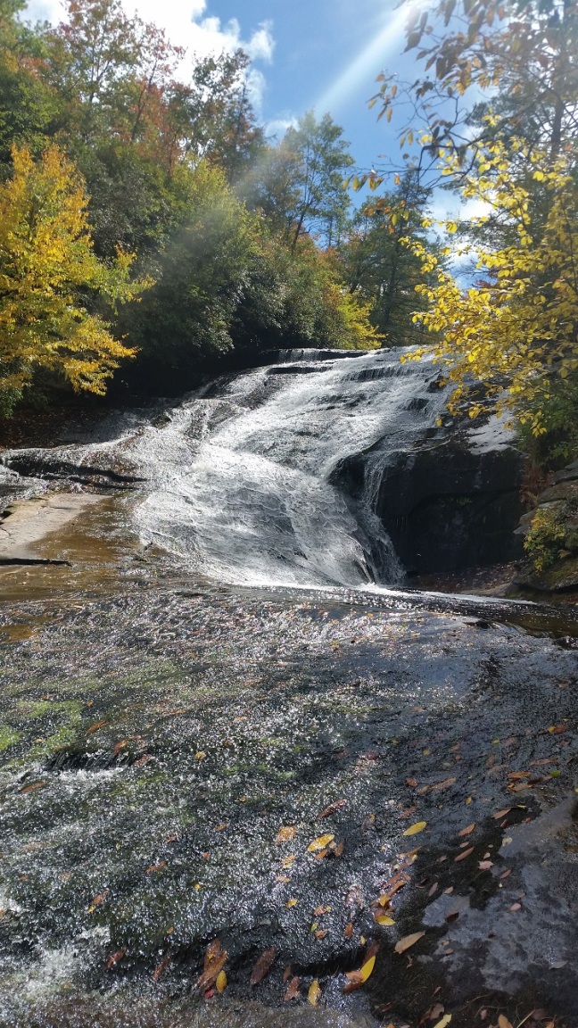
Once you find this little social trail, continue following it through the mountain laurel along the river, with your ears open for the sound of waterfalls. Not more than a minute of walking after you get on the social trail you will hear Mack’s Falls. You can get down to the river via another social trail to check it out.

After you’ve enjoyed Mack’s Falls, continue down the river. You are listening for another waterfall now! The trail will be hard to follow in places, and it does climb up the hill sometimes if there is a sharp bend in the river that makes the bank too steep to follow. The next waterfall is Pothole Falls, which can be reached after about 5 minutes of mountain laurel crawling.

After Pothole Falls just keep walking the river bank. The trail will become easier to walk, (fewer overhanging limbs and crawls under mountain laurel), and eventually you will start to hear people and lots of falling water. You are approaching School House Falls. At this point the social trail really truly looks like a trail. You will need to keep an eye out for a well worn trail heading DOWNHILL. The social trail you are currently on is going up hill – and that’s not where you want to go! The downhill trail you desire is BEFORE you are really on top of School House Falls. It is well worn.
Take this trail down and you will come up along side of School House Falls on the opposite bank from where the forest service trail reaches the falls. Usually there will be a lot of people here, so probably not the best place to stop for lunch. But the falls are cool.

The trail continues on the opposite side of the river from where you came in on the social trail. This is a very well maintained trail with a boardwalk. Follow it. This should be trail 474. You will come up to a river crossing to your right. Ignore it. You want the second river crossing where the wooden bridge runs directly in front of you. Cross the bridge or use the gravel horse ford to the right of it. Either way you come up to the intersection of 474 (Panthertown Valley) and 451 (Powerline Road Trail).
You want to go right onto Powerline Road Trail (#451). Go up the mountain, pass North Road Trail (#453), and at a bend in the trail is a noticeable social trail leading down hill. This one will become faint as you go down, but listen for the waterfall. You will eventually reach Warden’s Falls. There is another social trail on the other side of Warden’s Falls that should go up to Devil’s Elbow Trail (#448). As memory serves it is at the TOP of the waterfall where you need to cross to find it.
Climb the steep, but short trail back up to Devil’s Elbow Trail. Go left, continuing down the trail. Look for your next social trail – which will lead you down to Jawbone Falls and Pitillo’s Pool. I found this trail the most difficult of all the social trails to follow. If you get lost, just keep heading down hill. There is a handy creek that if you hit upon it you can follow out to the river.

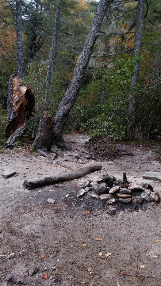
At this point you can go back out the way you came, or if like me you got kind of lost on your way in, follow the river bushwhack style. You’ll stumble on a campsite. Walk out of the campsite and into the river. There will be an obvious cascade down river, (Riding Ford Falls – not viewable) and across the river a large expanse of rock face and an obvious trail dumping out onto it. Walk down the river a few feet and look. You will see the actual forest service trail crossing just at the top of the cascade, (big holes among the mountain laurel). Stay on the east side of the river and walk up Riding Ford Trail (450) to Devil’s Elbow Trail (448). Go left, continuing down Devil’s Elbow.
This one will be more difficult. There are several drainage ditches running off the trail that look like social trails. Hint: If the trail ends after 5 feet…it is for drainage, not for people. After the drainage ditches end and you’ve walked for about 3-4 minutes, you should find the obvious social trail going down to Elbow Falls.

After all the bushwhacking, you can easily return to the trailhead via Devil’s Elbow. Devil’s Elbow dead ends into another trail (#474), so hang a left to go back to the parking lot. There is a nice powerline cut based view before you reach all the switch backs.
BE WARNED
- You will get lost. Everyone gets lost. Bring a good map specifically made for Panthertown and insure you have plenty of time to find your truck again. Or, alternatively, bring some extra food and see if one of the many campers in the forest will let you bunk with them for the night since your car is still mysteriously MIA.
- Bring a headlamp or light if you are planning to hike late in the day. The sun goes down fast in the mountains, and again, you’re probably going to be lost at some point.
- The usual thing about only let the water fall off the top of the waterfall and not you, your dog, or your sucker eating dependents.
- The parking area is small. Plan to park on the gravel access road instead of parking at the almost guaranteed to be filled parking lot.
- Watch for pink or orange ribbons on trees as you walk. These generally, (but not always), mark the entrance to social trails that lead down to interesting things like waterfalls, pools, and good campsites.
In sum: If your husband follows you through a blackberry and chimney thorn infested bushwack when he knows you are totally lost and don’t have a clue what you are doing – and still doesn’t complain, you owe him a pizza. Maybe 2 pizzas.
