Apparently it’s seriously in vogue to drive up onto the Blue Ridge Parkway around Asheville and watch the sunset from one of the many overlooks. Of course, that would be kind of boring for a hiking oriented website, so instead you can drive up to the Blue Ridge Parkway near Asheville, hike up to a real live firetower and watch the sunset from there. Cause that’s how we roll.
Is it goat approved? This particular hike, clocking in at less than a mile to summit, is very goatable, but is also highly popular with various groups of people so ask yourself if you’re willing to pose for photos before putting the goat in the car.
How you get there: Google Frying Pan Mountain Lookout Tower or you can just drive to the large pull over at the base of the road up to the tower here: 35.395021, -82.768824.
Time for the hike: 0.8 mile up hill to the tower and a significantly easier 0.8 of a mile downhill back to the car. The uphill is uphill the whole way on a gravel road.
Best season do to this hike: Spring, fall, or summer. The parkway has sections closed in the winter and its important to remember that during sunsets the change in air temperature from the glowing ball of nuclear death going around the side of the dirt ball we live on causes a big change in air temperature and consequently a fair bit of wind on top of a mountain peak. Which is cold as hell during most of the year up here. Bring a jacket.
Trails to Take
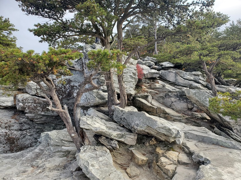
This is a nice easy hike in terms of navigation, but it is uphill the entire way. You start at the bottom at the pull over where the road come into the Blue Ridge Parkway and park there. Go around the forest service gate and up the wide, well maintained gravel road which leads you up the mountain past stunted trees, wildflowers, and a couple of balsams. At the summit a series of radio towers, a weather tower, and of course that big, rickety fire tower you can climb but not go inside await for your viewing pleasure. The tower is a climb at your own risk and teenagers frequently climb it by other means than the stairs, so you know, realize this thing is a tad rickety if you’re going up.
The practically manicured route up to the tower
View from the stairs – due to vertigo I cannot actually climb all the way to the top of most towers
Firetower
Mountain Laurel just beginning to bloom in June. Feels like being back in southern Canada.
In sum: Did you know that if you hold up your fingers horizontally between the sun and the horizon the number of fingers that fit between the sun and the horizon multiplied by 15 = the number of minutes until sunset remaining? I tested it, and it’s just about dead on.
Named after Roscoe C. Nicholson “Ranger Nick” of the Tallulah District who worked for the Forest Service from 1912 to 1952, this area is home to a short, scenic trail and a gorgeous stretch of road along trout fishing waters stretching from Tallulah Campground to Sandy Bottoms Campground.
Take a day (or a couple days) to come camp, hike, or bike this area to experience what Ranger Nick spent 40 years building.
Is it goat approved? This would be a great road walk and short hike with a goat. They don’t let goats on tree crew though, so I did this one sans goat. Hopefully I can bring him back in this direction in the future!
How you get there: You can stay at any of 3 campgrounds on the road – Sandy Bottom, Tallulah River, and Tate Branch or you can park at a tiny 2 car pull off right at the start of the Coleman trail located at 34.92997, -83.54593. I parked at the pull off. The trail head is almost on top of Tallulah River Campground though, so it makes a great run some energy off the kids hike since you can easily walk down to it without driving from there.
Time for the hike: About 2 miles total out and back for Coleman River Trail. The road walk is 6.46 miles total out and back. You can get a real hike in at 8.5ish miles if you do both. The trail peters off at a small cascade which is where I choose to turn around. More intrepid trout fishermen have clearly rock and mud scrambled further, but that cascade located at 34.939995, -83.540497 is probably as far as the house dog and the kids are going to go.
Season for the hike: Most seasons. This trail is worth hiking mostly because it stays on water the whole time, therefore summer, when you would be inclined to get in said water, might be the most fun. Don’t expect to get in the shade when you aren’t in the water though – a previous burn on the mountain side has left some areas with almost no tree cover.
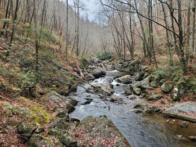
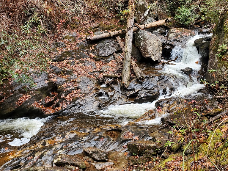
Starting at the 2 car pull in at the bridge the trail is not marked with a name, but with a sign that indicates you can hike in this direction. The trail goes upstream on Coleman River, staying always to the water. There are actual bridges (not all in great repair) and obvious tree clearance to keep the trail open. Numerous spots on the first 1/2 mile allow you to go down to the water and trout fisherman have certainly taken advantage. As you pass the 0.5 mile mark the river becomes deeper and more scenic, but also less safe to climb down to at the same time. At about a mile you reach a point where a pretty verticle mud scramble would be required to go further and it’s clear not many people have bothered, so I call that the turn around point. There’s also a semi-waterfall to stop and enjoy that makes a good book end for the hike.
When you get back to the trail head, because 2ish miles is a joke for a hike, you can walk up to the Tallulah River Campground and check it and its gorgeous hemlocks out (and use the restroom) or turn right and cross the bridge to enjoy a really rewarding road walk. The road passes through a fairly deep valley, following along and frequently crossing the Tallulah River. Trout fishermen and a variety of motorcyclists provide additional entertainment as the sound of flowing water follows you the whole way. It’s really very beautiful, with huge boulders among the water and the burnt trunks of long since burned out trees on the far mountain side. The route in is slightly uphill, but not grueling or anything. After about 2.15 miles, (at 34.95074, -83.55259), you come up to this crazy huge car ford where you basically drive down the Tallulah River about 20 foot in the river bed to cross. It is clearly popular with the local jeepies, and shallow enough to cross on foot.
Just beyond the ford is Tate Branch Campground at 2.47 miles. Currently closed for renovations it will reopen in March 2023. At 3.23 miles you reach Sandy Bottoms Campground, which is right at the edge of forest service property before you get into Tate City. This is probably my favorite of the three campgrounds, with its wispy young hemlocks and the dams in the river to create trout holes. Closed for the winter, it is a beautiful and serene place to have a late lunch before walking the 3.23 miles back (which is mostly mildly downhill!).
Coleman River Trail plaque stuck to a boulder a hundred yards are so from the start of the trail
Coleman River Trail
Cascade where the trail peters out
Roadwalk along the Tallulah River
The unusually long ford across the Tallulah to the jeep trail
Sandy Bottoms Campground
In Sum: The forest service was founded in 1905, so Ranger Nick was a real forerunner to join what amounted to a poorly funded start-up company in charge of managing something that had never been managed before and was probably full of squatters and people setting it on fire. Though, in fairness, it’s pretty much the same way today 🙂
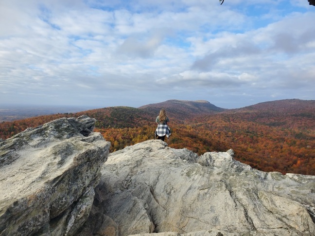
Okay, so when my sister was all like “hey, this is a sunset hike” and she said we should hike it in the morning I was, honestly, a tad suspicious that maybe we weren’t going at quite the right time of day for you know, absolutely awesome conditions. However, Hanging Rock is exactly what it advertises – a very large, very tall rise of rock that has an amazing, commanding view of the entirety of Hanging Rock State Park and much of the surrounding area.
Which is like fricking awesome regardless of what time of day it is.
Is it goat approved? No, this is a show piece park – high traffic, and most of that traffic is not animal friendly. I actually got kicked out of this park once with a goat.
How you get there: The parking lot the trail goes out of is located at 36.39522, -80.26525.
Time for the hike: 1.3 miles one way, 2.6mi out and back with significant up hill. The view is worth it, but you will have a bit of rock scrambling as you approach the top of the rock.
Best season to do this hike: Autumn, winter, or spring. I wouldn’t do this in summer purely because…well, it’s uphill and it’ll be hot. The leaves in fall are beautiful. The starkness of the rock in winter and the greening of the leaves in spring would also be beautiful. And all of those can be done without roasting to death!
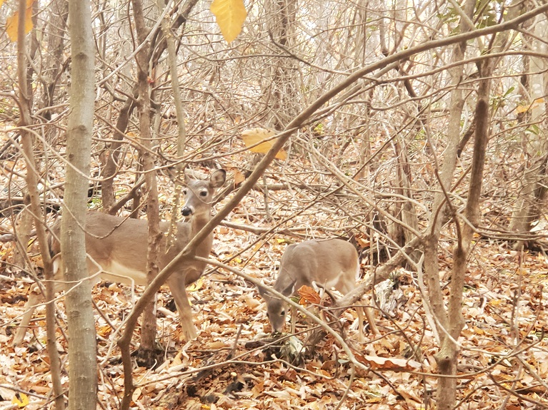
You start at the parking lot with the ranger’s station in it and the trail is actually a paved sidewalk initially that goes down from the parking lot into the woods. The trail changes from paved to dirt/gravel after maybe 1/4 mile then begins an ascent through pretty boring hardwoods, though the local deer are almost tame and pose for photos. Wolf Rock Trail comes off to your right, and then you turn sharply and begin the final ascent to Hanging Rock.
The dirt trail becomes stairs until it reaches the base of the rock, then the remains of a stone staircase along with strewn stone make up the remainder of the trail as you circle around to the back side of the rock and complete your climb. The top is mostly rock with many short stunted pines and oak trees. There are even a few spruce, which is pretty uncommon in the Carolinas! There are huge boulders to climb on, and if you are stupid or have zero fear of heights you can walk out to the edge of the rock (there are no fences). Personally, I like to live, so I take photos of people who like to walk out to the edge and stay the hell away from it myself.
It’s pretty cool, and then it’s an easy 1.3 miles all down hill to the parking lot.
Deer along the trail
View from the summit of Hanging Rock
Rock with stunted pines on the summit
In Sum: Fall – Nature’s way of throwing a party includes compostable confetti
One of the great conundrums of life is that everyone wants to live in a suburbia, (a place where everything is conveniently nearby but you still own a house), and no one wants to live in suburbia (because everyone else lives there so you have an HOA and that house ran you $400,000). To deal with this some awesome people banded together and said no, you can’t blow up the amazing massive boulders to build a subdivision, we’re turning this baby into a preserve. Thank you Southeastern Climbers Coalition for giving something to the future besides a 7 lane freeway and a Starbucks!
Is it goat approved? Oh man, a goat would love this place. However, I can’t recommend bringing the goat during normal business hours because it might be disruptive for the climbers for which this place was created. In the rain though, when nobody else would want to climb? A goat would be pretty awesome. The rear of the preserve is also less heavily climbed than right next to the parking area, so that would make a way better hang out for goat rock climbing.
How you get there: The parking area is located at 33.721847, -84.564150. Parking is behind a gate that you must register online to get the code for – the registration is free, but it does require you to certify you will not trash the area. Google it – I’m not providing the link here because this is one of those things you shouldn’t make too easy I suspect. The code will get you through the gate, after which you can park or drive down the two track to a second parking area.
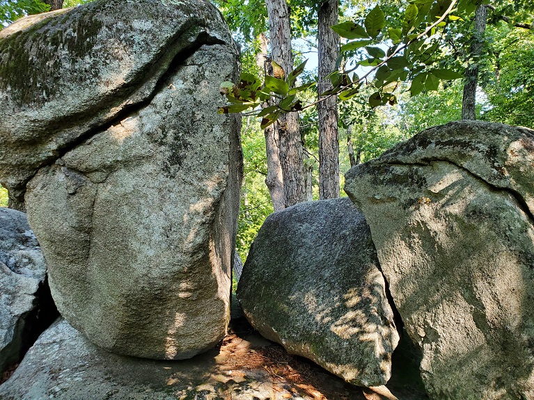
Time for the hike: At best you’ve got maybe 2 miles, maybe less of walking here between scaling boulders and walking around the small pond. There are no official trails, but many unofficial trails running among the boulders. The boulders range from small kid and timid girlfriend to actual rock climber difficulty. There are caves and various interesting formations that both experienced climbers and people who get vertigo on a six foot ladder can enjoy.
Best season to do this hike: I think any time, but the rocks are best scaled when dry.
Trails to Take
From the front, first parking area if you walk up the two track you can get to your first bouldering areas on the left and right. Right hand one is smaller, but with a small cave. To your left you can go into the boulder field…and just keep going. The trails will lead you to various boulders of various difficulty, from running up them to actual climbing and jumping from stone to stone. The foot trail(s) descend down to a rough and ready crossing of a small boggy creek at the pond, then up the hill again to more boulders just before you reach a road at the subdivision.
Coming back down there is a paved path around the pond, long fallen into disrepair and covered in downed trees that’s fun to go around, then you can make your way back via foot trail to the rear of the boulder field, passed the outhouse and to your car. It sounds short, but we spent close to 3 hours here on bouldering and walking around. For a Sunday in passable weather it was not super crowded either.
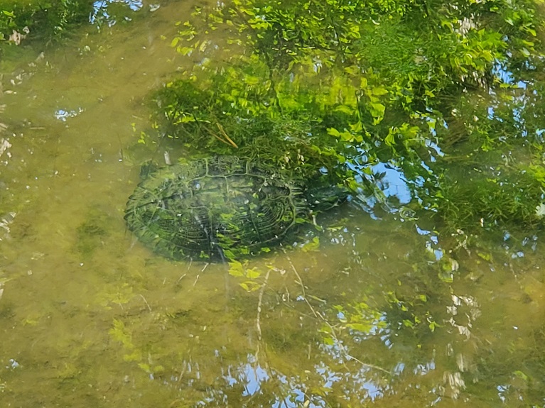
Turtle in the pondPondOld mining marks from damaging the boulders
In sum: When you are going rock climbing and you aren’t bringing a goat, bring a friend who is good at climbing to use as your anchor point. Just don’t yank them off the rock or you may lose said friend!
This is the wettest desert hike I’ve ever been on, but don’t think that 85F water will save you – it’s too hot to cool you down. Don’t count on the wind either – it feels like someone turned the blower on on the fire place into your face when the outside temperature was already over 100F. Then there’s the sand…that gets…absolutely everywhere…
However, the scenery is amazing (and not just the fort). The wildlife is unbelievable – huge crabs lounge in the surf while hermit crabs scuttle among the waves. Ghost crabs (big ones) dive into burrows as you pass. Fish large enough to eat come right up onto the shore then flip a fin to follow the receding waves. We even spotted dolphins just past the breakers and were serenaded by red wing black birds in the marsh reeds. It makes you wish every beach in the US was a protected shore like this, the standard tourist beaches are downright lame in comparison.
The fort is also pretty awesome. Fort Massachusetts was basically a pork barrel project before it was called a pork barrel project. While the idea of putting a fort near the newly annexed territory of Texas made some sense in the 1800s, the feasibility of building on Ship Island was considered cost prohibitive. A congressman from Mississippi pushed the funding bill through though, mostly by firing the first engineers who said it was a dumb idea and hiring some more that said it was a less dumb idea, (and also pointing out that the deep anchorage at Ship Island was used by the British in 1812 to attack New Orleans).
However, before the fort could be finished Mississippi succeeded from the Union, and after an aborted attempt to occupy and finish the fort due to incoming Union forces the Confederates torched the partially completed structure and left a hilariously backhanded letter to go with the smoldering ruins on the burning hot, exposed, water-less island stating ““In leaving you to-day we beg you accept our best wishes for your health and happiness… on this pleasant, hospitable shore.”
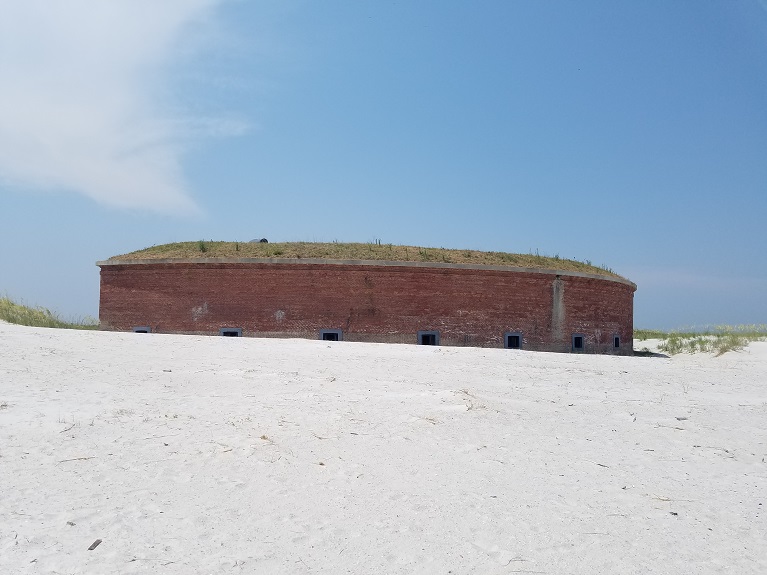
Life on the island for a Union soldier was often mercifully brief – nearly 230 soldiers were buried here that died mostly from disease due to the lack of clean, fresh water and the harsh environment. Many of these bodies were reburied at the Chalmette National Cemetery near New Orleans after the war ended, today you won’t find marked graves on the island. You also won’t find the numerous wooden structures that once serviced the fort such as barracks, bakery, mess hall, and hospital. You can, though, still find the fabulous brick fort and the remains of the base of the Ship Island lighthouse, lost to time due to a camper’s out of control fire in the 1970s.
The last active ordinance officer to maintain the fort’s cannon was retired in 1903, after which the lighthouse keeper alone maintained the fort and lighthouse structures. In the 1960s a “Save the Fort” campaign got the island transferred to the Park Service, after which years of restoration of both the fort and the sand beach in front of it brought the structure back from the brink. Today children race up stairs that men once carried cannonballs to kill people with up, a beautiful and fitting end for a unique historical structure.
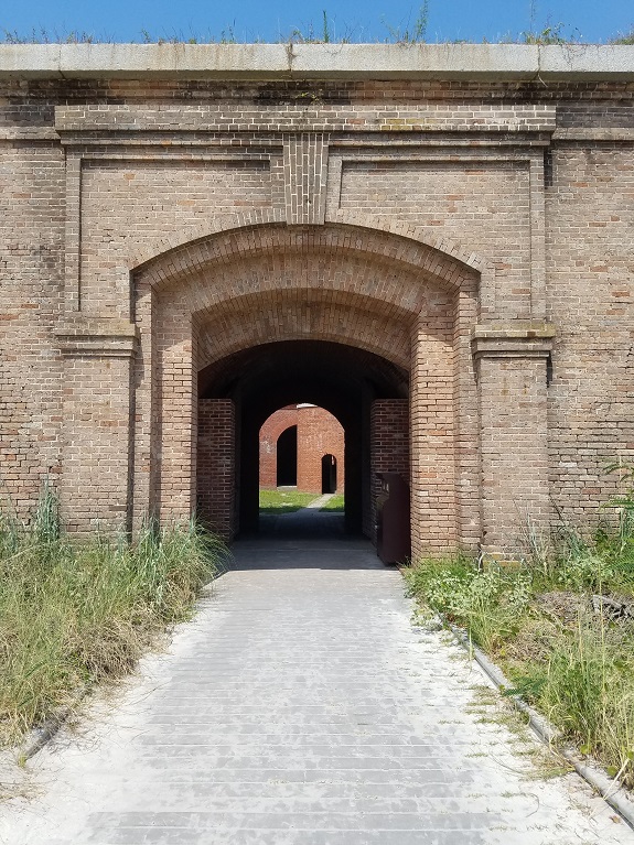
Fort EntryHot Shot Furnace in the fortFort from the beachOne of the cannonsInterior of the fort
Is it goat approved? The commercial ferry over does not allow pets, you’ll need to find a friend with an ocean going boat or a really accommodating fishing charter to get a goat out here and when you do you’ll find there’s no water for it. Or shade.
How you get there: There is a commercial ferry that can take you over, google it! Alternatively find some friends with a big, big boat.
Time for the hike: We did a 9 mile loop, around the southern end of the island taking in the dock, fort, cabana/beach area, light house ruins, and some of the interior sandy areas. The island itself is technically ~7.47mi ONE WAY, so if you just like suffering I guess you could do it all, but be careful – the island changes shape regularly. The northern end was cut off several years ago, but more recently a sand strip reformed between the area with the fort and the upper area. So look at google maps satellite and then realize it may no longer be accurate and the ferry leaves at 5pm sharp!
Best season to do this hike: If you don’t want to feel like you’re hiking Death Valley with 100% humidity you will want to go in spring or fall. If you want to feel like you’re in the desert because it’s too $$$ to go to the ones out west though, summer is a pretty close facsimile to the desert areas of Utah. With 100% humidity.
Trails to Take
The ferry starts off at the dock and you walk down the dock and right past Fort Massachusetts. It’s not open when you first get there, it opens at like 10:00 AM so instead of hanging around like a creeper go down the boardwalk, past the nice picnic shelters and to the beach where they rent umbrellas and stuff for people who want to lay around for the day. Which no one reading this post is planning to do, so pass through that and hang a right to go along the beach.
The sea oats in the dunes are really good right here and you’ll see red wing blackbirds (and hear them) in the marsh land just beyond. Those huge black things in the sand just under the surf? Those are crabs. Watch what shells you pick up too – there’s a lot of hermit crabs on this beach despite the level of tourists. If you see something about the size of a softball skittering away across the sand those are ghost crabs. They seem to think if they can’t see you you can’t see them, which makes getting photos of them surprisingly easy.
The hike goes along the shore, then out to the point and back around to the fort, by which time you can do some boat and people watching as people with personal boats arrive and set up camp on the beach to do…whatever is you do if you actually come to the beach to sit down. I don’t do that, so I’m under the impression it involves sunscreen, kites, and fishing poles. Also hats, hats seem to be a big feature.
Redwing BlackbirdSeashell diversity on the islandFiddle Leaf Morning Glories
By the time you get back to the raised walkway and the dock the fort should be open and you can stop and take in some awesome history – despite being built on a barrier island it is surprisingly intact, including its water storage system that collects rain water and deposits it into a cistern under the fort, which is some impressive and still functional engineering. Of course, that cistern couldn’t sustain everybody who came to the island during the Civil War. The union tried digging wells all over the island, but to no avail (and subsequently, to cholera, dysentery and other contaminated water diseases). There is a fresh water lens (which provides water for the bathrooms and the snack shack) but it’s over 400ft down. For comparison, my water table in the mountains is only about 500ft down. That’s really fricking deep.
From the boardwalk you get back to the beach with the umbrellas for rent and now you hang a right and go up the shore. This is the best part of the hike. The number of people quickly dwindles (both those from the ferry and those on private boats). The shelling gets better and better, the crabs and hermit crabs more numerous. It’s on this side that we saw the dolphins. We hiked until we had left behind the main island, then realizing that google maps shows the island as two pieces but the satellite shows the island as one and we had to get back by 5pm we crossed the football field width of the sand strip that connects the two sections of the island with significant plant life and started walking back on the landward side of the island.
Which was all well and good until we got to that cut in on the map image – it was a lot smaller on the day and time we came, but it was still a big, deep water filled hole that people were fishing like crazy on – too deep to reliably swim and to cross to the far point required marsh, and I’ve had enough being sucked into quicksand and bog to last me a lifetime. Fortunately, the forest service patrols the island on a side by side and they had left a really obvious trail in the sand (tire tracks) that we followed back through the dunes to the seaward side of the island so we could walk back. The best shelling (and scenery) was actually on this section, but it was brutally hot and SPF 50 sunscreen and 3 liters of water was insufficient. Had to go buy more hydration at the snack shack when we got back to it. This section reminded me very much of hiking in Canyonlands out in Utah and Arches National Park, but without the arches, more water, and a wall of continuous wind the entire time. Very interesting.
Anyway, once you get back, pick up a drink (or 3) at the snack shack and then mosey on back to the dock so the ferry guys don’t get angry at you for being late.
In sum: I don’t know how you sum up this one because it happened during a really difficult point in my life except to say that the best representation of the human experience I have ever found is the song Dango Daikazoku. Human life is truly… all sadness and all happiness rolled up into one.
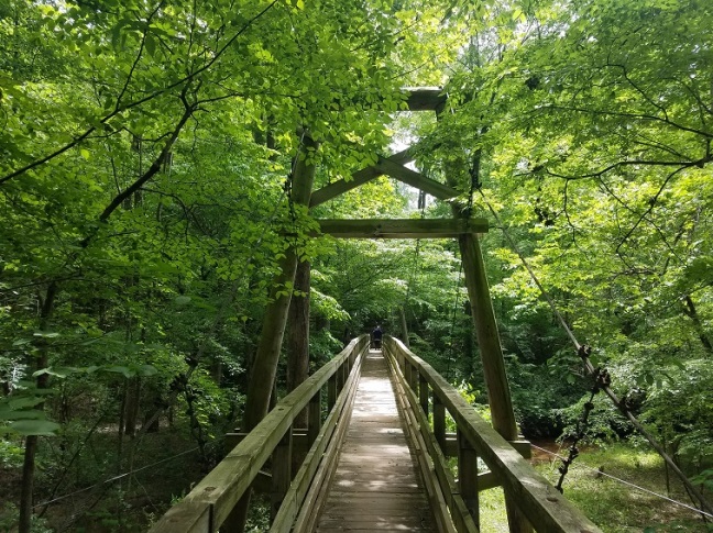
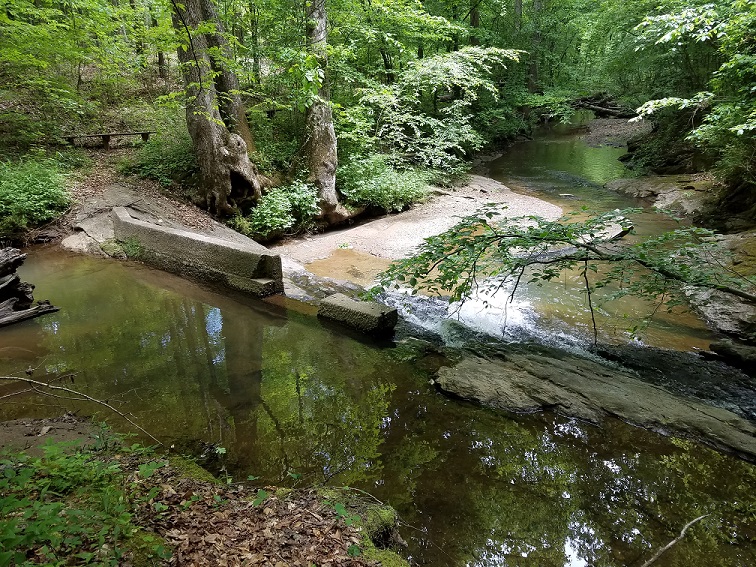
The Bridge Loop has several bridges on it (as one would expect), however, I think the name comes from the giant and highly enjoyable suspension bridge located about halfway around the loop. Worth the hike just to jump on! As an added bonus the hike has significant portions traveling creek side and an assortment of wildflowers (trilliums, jack in the pulpits, possibly paw paws) to enjoy. For those more into history the trail also passes what may be the ruins of a creek weir – a concrete structure used to measure creek water flow – as well as old rock foundations.
CHICOPEE WOODS HISTORY
The area that is now Chicopee Woods/Elanchee Nature Preserve used to be the watershed for the local Johnson and Johnson plant and its mill village, Chicopee Woods. In 1927 Johnson and Johnson built the Chicopee Mill in Georgia due to the proximity to cotton production. The mill was used to produce sterile surgical gauze, cheese cloth, and bunting. The plant utilized water from Chicopee Woods after filtration at a purpose built water plant. I have not yet found the water plant itself, but that’s on the list of old sites to locate. The weir found today may have been used to monitor water supply for this filtration plant.
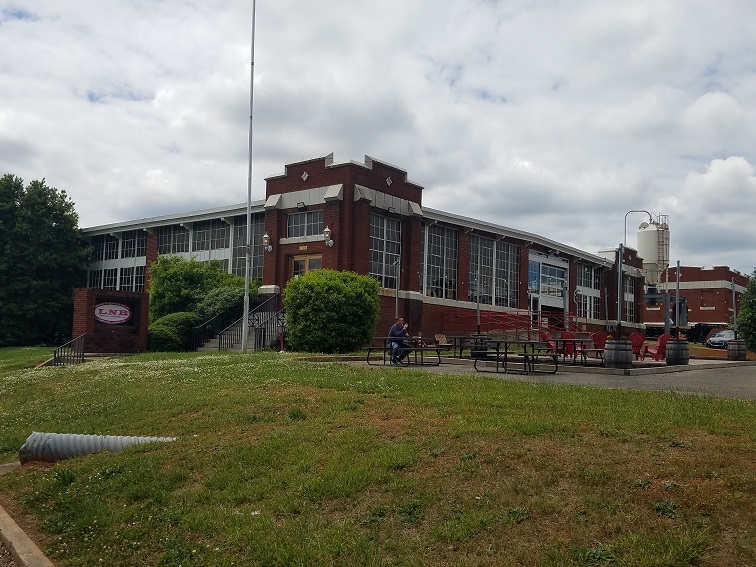
While the original Chicopee Mill closed down in the 1970s the mill itself (and its village) still exist. The mill is now home to a brewery and a variety of small businesses. The unique 1920s architecture and what was for the time revolutionary mill design can still be experienced by visiting the bar at the brewery, which lies just across from the entrance to the nature preserve inside the old plant office. The village can be driven through as well.
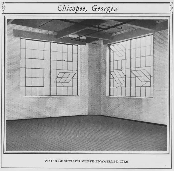
When first built these houses were a cut above the typical mill village house of the south – they had buried electrical lines, the aforementioned dedicated clean water plant, modern appliances, indoor plumbing, hot water, and fireplaces. While all this might have a practical application for the factory owner and the health of his workforce, Johnson and Johnson went one further step beyond the typical mill village design – they offered 31 different blueprints the prospective new homeowners could choose from. Today that can make Chicopee Village hard to identify as a classic mill village from a distance, because it doesn’t have the rows and rows of tightly packed, identical shotgun houses. However, it also makes the mill village even today a desirable place to live compared to the substandard (though newer) housing that surrounds it.
The Chicopee Mill in operationChicopee Mill as it looks todayBrewery in mill officeThe interior of the mill – compare this to the poorly lit, poorly ventilated, and often dusty interior of a traditional cotton mill of the 1920s.
Is it goat approved? No, no pets allowed. But there is a silver lining – it also means no dogs too! Enjoy a wonderful hike free of random off leash dogs chasing wildlife, dog poop, dogs jumping on you, and the perpetual hassle of waiting on the grumpy owner to get their dog back under control.
How you get there: Google Chicopee Woods Nature Preserve. The parking lot to start in is at 34.244872, -83.833773. Note there is a $5 per car parking fee to enter the grounds and there is a manned guard shack to collect that fee. The park is gated and the gates are closed when the park is not open. They also don’t allow ebikes for some reason, possibly due to the new fat tire models that are basically electric dirt bikes tearing up the mountain biking trails.
Time for the hike: 2.77 mi loop with rolling terrain. If you’re used to the mountains the hills will be a breeze. If you aren’t used to the mountains there are moderate and fairly short uphills.
Best season to do this hike: Any time would be good.
Trails to Take
Starting off at the parking area walk to the end of the parking area, past the trail signage and into the trees. The bridge trail comes off to your right and down hill, following the green blaze. It descends down to the purple blaze backcountry trail, then follows the creek for a ways. You cross your first bridge over the creek a few minutes later, but don’t worry, it’s not the bridge you’re looking for!
First BridgeRemains of creek weir
Right after you cross the bridge hang a left on an obvious foot trail to go down to the remains of a concrete creek weir – a concrete structure used for measuring water flow. An abandoned road bed once led down to this location, and it is possible the creek weir was part of the water management and filtration system that supplied the plant and the Chicopee Woods development. Several more old road beds will be glimpsed as you continue along the trail.
The trail intersects with the Lake Loop and near this junction is the awesome suspension bridge that lent the trail it’s name. You cross this piece of awesomeness, which is mostly spanning a low spot and not a particularly large or aggressive creek (though there is water) to continue along Bridge Trail. At 34.233824, -83.830644 off to the right of the trail are several old stone foundations nearly buried in the leaves to see – a sign that despite the nature center’s website’s comments about the area being poor farming ground some people may still have lived or worked on this land prior to the building of the plant.
Suspension BridgeStone FoundationsMay apple on the hike
Trilliums, may apples, and pine moss accompany you for the remainder of the hike, which is pleasant but not exactly show stopping. Stick to the green bridge loop all the way back to the parking area, with a short stretch were you’ll join up with Elachee Creek Loop before Bridge Trail goes up hill to the parking area.
In Sum: When you can get a free ride into Chicopee Woods take it 🙂
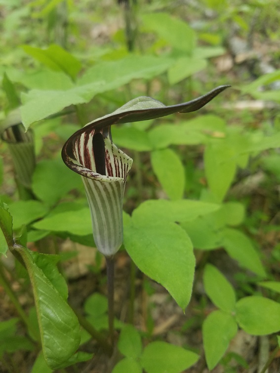
I wasn’t expecting much from Chicopee Woods/Elanchee Nature Preserve because it’s practically in downtown Gainesville, and not exactly the nicest part of Gainesville. However, despite the $5 entrance fee there is enough mileage here to make it worth visiting and the nature is really nature. No groves of invasive privet to hack through or ditches subsumed by honey suckle and kuzdu for this place – instead it’s a wonderful spring hike full of trilliums, two species of jack in the pulpit (the highlight), blue eyed grass, green and gold, and a forest of bird song. Much of the trail winds along some type of water course, and that combined with the shade of the trees keeps the hike cool.
And don’t forget there’s also the owl at the nature center to stop and see!
Is it goat approved? No, no pets allowed. But there is a silver lining – it also means no dogs too! Enjoy a wonderful hike free of random off leash dogs chasing wildlife, dog poop, dogs jumping on you, and the perpetual hassle of waiting on the grumpy owner to get their dog back under control.
How you get there: Google Chicopee Woods Nature Preserve. The parking lot to start in is at 34.244872, -83.833773. Note there is a $5 per car parking fee to enter the grounds and there is a manned guard shack to collect that fee. The park is gated and the gates are closed when the park is not open. They also don’t allow ebikes for some reason, possibly due to the new fat tire models that are basically electric dirt bikes tearing up the mountain biking trails.
Time for the hike: 5.46 mi loop with rolling terrain. If you’re used to the mountains the hills will be a breeze. If you aren’t used to the mountains there are moderate and fairly short uphills.
Best season to do this hike: Any time, makes a great hike in the spring (April to first week of May) for wildflowers.
Trails to Take
Starting at the parking area proceed to the green connector trail where the parking area meets the paved entrance road. The green connector (technically the Bridge Trail) drops down to a yellow trail named Elachee Creek Loop. Hang a left, walk along the yellow trail to Geiger Gorge Trail and then hand another left to go up to the parking area of the nature center. There is an outdoor enclosure with an owl you can see on the back side of the nature center even when the center is closed. Worth a visit.
Owl displayNature Center
Beyond the nature center (sort of behind it and to the left) is Dodd Loop. Start off on Dodd Loop and you will drop down a series of drainage ditches until you reach the creek, wherein trilliums and the first Jack in the Pulpits can be seen. The trail continues along the creek, which is nice and not overgrown with invasive species. Look out for what appears to be paw paws and sweet shrub. May apples are to be found in patches along the forest floor.
When the Dodd Loop intersects with Ridge Trail hang a left onto Ridge Trail and continue the hike. The trail continues through fern filled woods until reaching Bridge Loop. Hang a left on Bridge Loop, followed about 3/4 of a mile later by a left on Lake Loop. This will bypass the highlight of Bridge Loop, which is a giant and rather fun suspension bridge, but it takes you on the shortest path to reach the lake/pond.
Turtle at the pondSweet ShrubFern carpetTrilliumGranddaddy long legs
Lake Loop passes some boggy areas, but never fear, the lake is an actual lake, just keep going. For some reason this stretch in spring reminds me of New York or a colder climate. Maybe it’s the lack of honey suckle growing on everything.
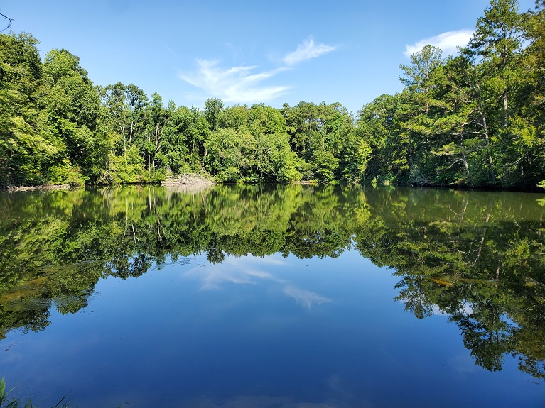
You come up to the lake and the parking area for it later, and there is a great (if nearly underwater) viewing platform of the lake and it’s waterfowl, turtles, etc. This parking lot is also fee based and no fishing or kayaking is allowed in the lake (remember, nature preserve). The Lake Loop continues via a short connector from the viewing platform up to the dam, where the Lake Loop crosses the dam.
After the dam hanging a left onto the Chicopee Backcountry Trail. There’s all this signage about how hard this trail is, etc. and maybe it’s hard if you wanted to take a short hike with your three year old, but if you regularly hike this is a beautiful and not hard at all way to get back to where you left your car. The trail starts off along the forest, crossing several streams, most of which are jumpable or have rocks for crossing.
There are various hilariously named areas on this trail, most of which will make you feel like you’re in a videogame for emotionally sensitive grade schoolers, (Pine Straw Pass has become an inside joke now between my husband and myself). Be prepared to not take anything too seriously. The only adult sign on the trail is the Scobey Stack which may be the remains of a homesite, but I keep drawing a blank on the history. There are other areas of potentially human disturbed rock nearby, but again, no significant information has been forthcoming on this yet, hoping to get a chance to peruse old maps for what this stack and the other remnants might have once been. There are a large number of old roadbeds in the nature preserve, so while this area is believed to have not been farmed, it may once have been an area of active moonshine stills and subsistence level agriculture.
The trail eventually winds up passing through more open forest where the second variety of jack in the pulpits may be seen, along with carpets of ferns. When the trail intersects with Bridge Trail hang a left on that and go uphill to the pink trail, hang another left and you’re at the end of the parking lot you left your car in.
In Sum: Unfortunately Troll Glen was fresh out of trolls when we got there on the back country trail. Though I guess I didn’t have my billy goat with me on this one anyway.
Like the more well known Stone Mountain, the area of the Arabia Mountain PATH Trail contains two monadnocks, Arabia Mountain and Panola Mountain. Monadnocks are classically large granite outcroppings that rise above the surrounding landscape, however, due to a lack of heat in the magma during formation Arabia Mountain is actually a granite precursor called migmatite, while Panola Mountain, which is the terminus of today’s ride, is granite. Interestingly Panola mountain was not heavily quarried because despite being granite it was of inferior hardness to Arabia’s migmatite. Therefore you’ll get to see quarry ruins on Arabia, but a mostly undisturbed environment on Panola.
Arabia Mountain used to be a rocky place to live. Known in the 1800s as a sparsely populated area of dairy farms providing milk to Atlanta, to make ends meet on the rocky soil some farmers had backyard quarries. A commercial quarry opened on Arabia Mountain in the 1800s quarrying building stone and then making its fortune in the production of granite grit for chickens. It seems rather wasteful that we cut up such an unusual formation so it could essentially be rolled around in a gizzard and eventually pooped out the backside of a chicken, but hey, there’s now little tiny bits of Georgia composting all over the country now I guess.
So if something smells familiar when you’re visiting old homesites in other parts of the country, it might be a tiny remnant of Georgia decomposing in that old hen house…
Is it goat approved? Well, it has signage allowing horses, but this is a paved cycle oriented trail. There is definite signage that forbids hoofed animals on the monadanoks themselves near Arabia Mountain. I took a bike this time to scope it out, and I would say yes, you could take a goat on this but you won’t technically be allowed to go out on the rocks themselves at Arabia Mountain and you will have to have a goat that can handle cycles, some areas of high traffic, and walking along a sidewalk along a busy road. However, the level of traffic on the vast majority of the trail is low enough that you won’t get harassed by curious passerby every five seconds. I do plan to come back and try sections with Mule.
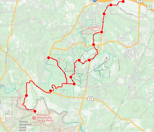
Time for the hike: I took a bike on this one, and with the side trails we did something like 30 miles out and back with one side trip to the Evens MillSite.
Best season to do this hike: I enjoyed November. I would say this trail is at its best in cooler weather because otherwise you’re gonna bake on all that concrete, and you’ll see fewer people.
Trails to Take
You can park at Stonecrest Mall (which is the easiest and cheapest). You then go up the entrance closest to the highway toward Mall Parkway to reach the paved trail – you’ll know you are there when there’s a dividing line on the sidewalk. Go up Mall Parkway slightly uphill to your right to the light. At the light cross Klondike Rd, then cross Mall Parkway and the trail begins. At first it crosses through some neighborhoods (okay areas, but nothing exciting) on what looks like an old rail right of way (later, when you reach the Arabia Mountain area boardwalk you can see an old railroad right of way concrete marker that is still sticking out of the rock face to confirm that some of this at least must have been an old rail right of way).
Dairy Barn and big field
Ruins in woods near nature center
You come out out and begin to bike along (but not on) Klondike Road till you reach a large field with an old dairy barn in the middle of it around a mile in. The barn can be visited (and frequently is). The paved trail passes the barn , turns and follows a private property line downhill. It straightens out, crosses Rockland Rd, and enters a nature preserve area with many side trails to swamps and other locations. This section is very busy traffic-wise!
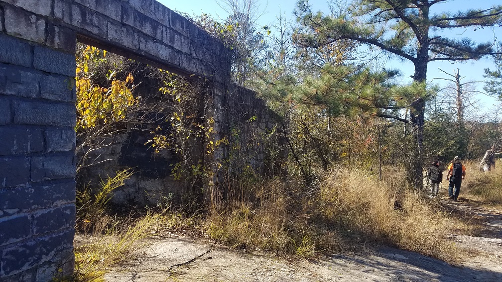
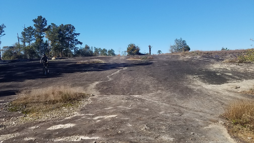
Passing close by the nature center buildings, the trail comes up along Klondike Rd again, and as you bike parallel to the road (but again, mercifully not in it!) begin to look to your right. Vestiges of the old mining operations will begin to appear, first what appears to be old warehouse foundations, and then later as you move away from Klondike Road and descend you can’t miss the old mine office with it’s stone walls and barred windows sitting at the edge of the open expanse of monadnock rock face. All ruins and the extensive rock faces are completely open to exploration, which adds to the fun, though signage in various locations discourages the use of skateboards, mountain bikes, and hooves animals on the rock faces themselves.
When you come back up to Klondike Road again, hanging a left and cross Klondike Road to join up on a nice scenic boardwalk along the rock face. Here you will see the rail line right of way marker mentioned earlier on the left hand side of the boardwalk sticking out of the rock. The board walk dead ends into south parking, which is usually packed – so don’t expect to park here. It’s also tight – some poor woman actually backed too far towards the tree and got her car stuck with a wheel in the air because there just isn’t space to maneuver. It also appears to be a hangout for the forest service, who may ask penetrating questions about goats and the rock face here is placarded as “no hooved animals”. Now, all that whining being said, this is the parking area to climb to Arabia Mountain, so if you came on foot and that’s what you want to do, you are in the right place. Otherwise, turn around and enjoy that boardwalk along the rock face again.
Mine office ruins
Arabia Mountain summit trail
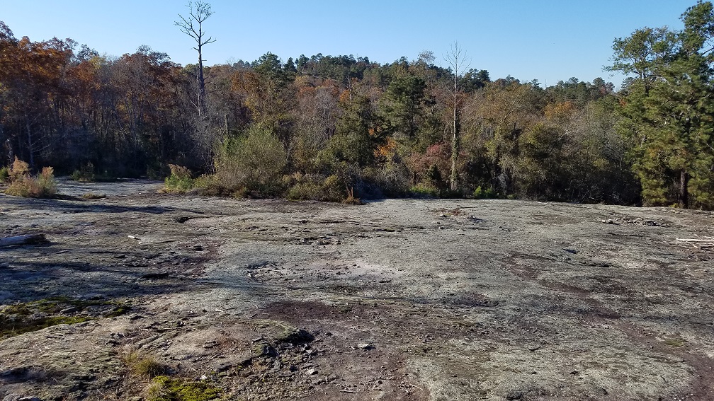
Extensive monadnock rock faces in the area
Return to the junction and continue on the PATH trail. The trail drops into the woods along some creeks with a view to nowhere, switch backs a bit, and drops some more. Cross North Goddard Rd, continue dropping in elevation, and eventually come to the cute covered bridge and picnic tables. Definite photo op area. Past the covered bridge you reach the junction to continue on the PATH or take a short sidetrip to Even’s Mill by hanging a right.
Even’s Mill is worth visiting, and a short jaunt on relatively flat trail brings you to the parking area on Even’s Mill Road. Some wall ruins are present around the historical signage in the woods near the parking area, and the main body of the mill ruins can be visited by going up to the road, crossing the bridge, and walking down to the creek on the far side. They can also be viewed in winter from the Even’s Mill Parking Area side. Kind of neat to see, especially in an area that is rapidly being overtaken by urban sprawl. The mill once ground grain for consumption and to produce that traditional southern coping mechanism for poverty – moonshine. There may also be some rock pylons from a historical African American church in the area, but I was not able to locate these.
Mill ruins at Even’s Mill site (with a geocache)
If you return down the spur to the PATH trail you can continue on the PATH up to Brown’s Mill Parking. Then cross 212, and ride up the old sidewallk that runs between the sewage spray field and 212. The path turns, moves away from 212 and into an area of rather hideous big ugly box style subdivision housing, and follows the perimeter of the sludge field around until you reach an area of woods and open field. It feels, if you spent a lot of time in the South’s piedmont areas, like an old farming track, and soon enough you come up on an old restored farm with some historic signage. This is Lyon Farm. The original founder of the Lyon family in Georgia came as a soldier in the Revolutionary War fighting on the British side. He was captured, saw an opportunity, and switched sides, going on to fight for the fledging United States and settling after the war in South Carolina.
In Georgia after the forcible removal of the native population a land lottery was set up to encourage settlement by whites throughout the North Georgia area. This decision drastically changed the face of the North Georgia mountains and surrounding environs. Examples of lottery allotments in this period include the dairy farming that occurred at the Cheese Factory camping site on the Appalachian Trail and the awarding of an allotment at the Auraria gold mining town to a guy who refused to sell any town plots – causing the US mint to build its headquarters further north in what became Dahlonega. Which is why Dahlonega is the county seat for Lumpkin County instead of Auraria, despite Auraria being the center of the gold rush.
The Lyons family is thought to have moved to into the area during this period of land lotteries, and may have benefited from receiving land through the lottery. Like many of the original families that arrived right after the removal of the Native American populations, the Lyons family continued to farm in the area until 2007. You can see the homestead remains of those families that received less fertile land and thus eventually died out, left, or were bought out during the Depression in Lake Russel WMA, Cohutta, and the Chattahoochee National Forest.
Flat Rock, one of the oldest historically black communities in the Atlanta area lies near here, and the area is still a bedrock of local African American culture. Not surprisingly the signage at Lyon Farms reflects the real reality of the south in the 1800s – Lyons farm was home to both the Lyons family and to a bunch of other people who did the heavy lifting and were not treated as human beings, but considered property just like the cows and the chickens, (and as my favorite author once wrote – the problem starts when you begin to think of people as things rather than people). After the Civil War, the enslaved workers on Lyon, South, and Johnson Farms came together to form the community of Flat Rock, which still exists.
From there, continue on the path into areas that feel more rural, and still like old farming ground. An unmarked pair of chimneys and old house foundation ruins of what once must have been a pretty huge house appear in the woods on your left. You can walk out to these and explore, it’s kind of awesome.
Lyons Farmhouse
Chimney stacks
Panola Mountain Overlook. I leave it to others to determine what exactly we were overlooking here…because adding the mountain to the view seems to have been overlooked to me!
Beyond this the PATH continues, entering Panola Mountain State Park. We biked up to the Panola Mountain Overlook, which was not really an overlook in the traditional sense, before turning around since we were past mile 10 on the trail and frankly, with the side trails 30 miles is about the max I was going to handle since I’m not a serious road biker. At that point, turn around and head back to enjoy more wonderful historical biking.
In Sum: While I don’t usually get into paved trails, when you buy an old Raleigh road bike with 1/2″ thick tires because you thought about going cycle touring…you really like it when people pave things!
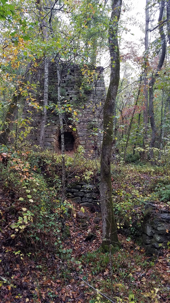
While there isn’t a ton of hiking with these, they make fantastic side trips if you are going to any of the other parks or areas of interest in western Georgia. These are all historical iron furnaces, dating from a period when Georgia was a major producer of pig iron. In fact, iron was such an important part of the economy that families operating iron furnaces had their sons exempted from service in the Civil War.
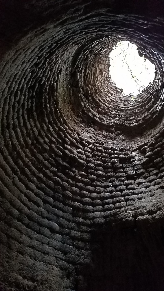
In operation, iron ore was brought to the furnace and loaded, along with limestone and charcoal These materials were loaded by pushing them on carts along a trestle that extended from a bank to the top of the furnace (referred to as “charging house” in the diagram below). To achieve the necessary temperatures oxygen was forced into the furnace by a waterwheel powered bellows that supplied air through the tuyere opening via a pipe. Often these water wheels were located close to the furnace, however, one example visited today (Diamond Furnace) had an air pipe running 50 feet from the waterwheel up hill to feed the furnace.
During firing the iron ore and limestone melted and flowed to the bottom of the furnace. The limestone would act as a flux, trapping impurities from the ore to allow pure iron to be formed. Pure iron is heavier than the contaminated flux, so it would pool at the very bottom and a clay plug would be removed once the firing was completely to allow the molten iron to flow out into the cast shedding while the contaminated flux, also known as slag, was collected and disposed of in slag piles.
To cast the molten iron the forge workers made use of a very ancient (and very practical) technique – they would construct beds of sand under the roof of the casting shed adjacent to the furnace. Into these beds of sand they would form a channel for the iron ore to flow down to a series of depressions in the desired shape of the final ingots. When the iron ore was released it would flow into these molds and cool – the process reminded people of see a bunch of piglets nursing on a sow, and so they referred to these ingots as “pig iron”.
A special shout out to the amazing man who has documented these furnaces, as well as numerous other kilns, mines, and ruins that form Georgia’s industrial heritage on both public and private lands. I don’t know him, but I love his website and the depth of his research, so check it out if this is your kind of thing – https://www.be-roberts.com/se/ruins
Is it goat approved? The ones at Pine Log WMA I would totally take a goat too, but Cooper’s Furnace is a little to county park-esque to be super goat friendly.
How you get there: See below under each furnace. Two of these are at Pine Log WMA, and the third is located at the aptly named Cooper’s Furnace Day Use Area.
Time for the hike: All furnaces are within 5 minutes of walking (or considerably less) from where you could park a car, except for the one located inside Pine Log WMA – if the front gate is open its 5 minutes, if the front gate is not you’ll have to hoof it along a few miles of gravel road to reach the location. I get the impression the front gate is generally open though.
Best season to do this hike: Winter. With all the foliage off the trees and brush you can get a better view of the furnaces and their surroundings.
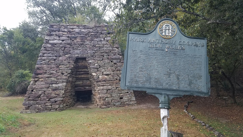
Cooper’s Furnace
Cooper’s furnace is the only intentionally preserved furnace on the list, and it is a beauty. It can be viewed at the aptly named Cooper’s Furnace Day Use Area. This furnace was built in 1830 as the very first iron ore furnace in the area. After it’s construction the town of Etowah was founded nearby. At its height the town had 1200 residents, a foundry for forming the furnace’s pig iron into railroad rails and spikes, a corn mill, a flour mill, it’s own post office, church, stores, warehouses, and school house. The yard engine from Cooper’s Furnace (named Yonah) happened to be at the town’s railroad depot one fateful morning and thus became involved in the Great Locomotive Chase of the Civil War.
During the Civil War in 1864 Etowah was put to the torch and never recovered. The town’s abandoned ruins were extensive and often visited for many years, until they were drowned during the construction of Allatoona Lake. The old town site now lies near the lake’s dam.
Today, all that remains is Cooper’s Furnace, which the park service has partially restored and maintained so we can go see awesome historical stuff!
Old bridge – the stone pillars in this photo can be seen as you approach Cooper’s Furnace at (34.154412, -84.770435)
Town of Etowah ruins now buried under Lake Allatoona
Diamond Furnace
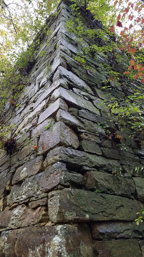
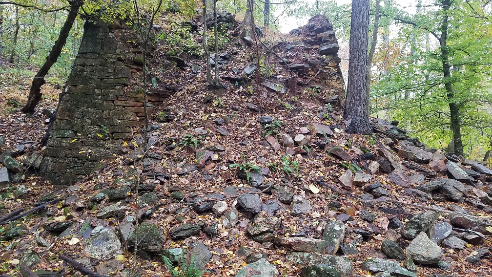
Diamond Furnace is located on the Pine Log WMA directly behind the ranger check station at (34.255325, -84.689371). This one went through a series of owners, who apparently changed the name frequently – my favorite old name was “Fire-eater Furnace”. While not as well preserved as other furnaces in the post, it is still imposing. This furnace you may notice is a long, long way from the creek! I too was confused and did some research when I got back home. It utilized a 50 ft pipe to pump air up to the furnace from a waterwheel located much closer to the creek. It is possible that this 50 ft pipe connects from the underground opening near the furnace to the possible exit I found below the slag heap (see hand drawn diagram), but given the advanced decay of the site who knows. In any case, its an interesting design, and the beauty of the brick arches within the tunnel itself was worth investigating it.
Heavily eroded Diamond Furnace
Different slag types found on the slag heap
Yes…I just realized I spelled furnace wrong…oh well.
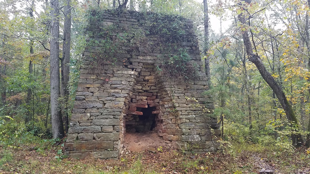
Lewis-Oak Grove Furnace
A popular spot to visit in Pine Log WMA this furnace is probably the most complete in terms of its original workings on this post. It can be found at (34.271095, -84.679733). It still has its tuyere pipe opening visible even (see images below). Located on Stamp Creek, this classically designed furnace used a long mill race to bring water to a water wheel adjacent to the mill to power the bellows. I did not find the slag heap at this location though – it is possible the large piles surrounding the furnace are partially built of slag, or since this was before the EPA and common sense, they may have just let it run into the creek.
To reach the site you can park on the gravel road along Stamp Creek. There is a concrete car crossing (no water flowing over it normally) over Stamp Creek if you find yourself on the wrong side. The trail is very visible and runs along Stamp Creek on the west side from the concrete car crossing, through some obviously odd looking hummocks, and up to the site. The only downside is Georgia is still Georgia, and in Georgia for some reason people camp right on top of points of interest with the attendant mess and destruction that causes. So you may find people camping right on top of the furnace as there is a campsite in the middle of where the casting shed probably sat.
Furnace from casting shed side
Tuyere opening for providing air just visible as the circular metal pipe in the bottom center
Waterwheel location with furnace in the background
Inside the furnace’s firing chamber
Mill race with rock walls
Stamp Creek
In Sum: When you are traveling in a relatively industrialized area, you do not expect to come around the corner to a flock of turkeys in the middle of the road right outside Cooper’s Furnace Day Use Area. After the ensuing chaos of swerving car and screaming turkeys, this particular turkey flew up into a tree and glared at me for a while.
A quick and dirty hike out to Preacher’s Rock overlook and down to Lance Creek Campsite.
Is it goat approved? No. This trail is extremely high traffic, going to one of the most popular campsites on the Appalachian Trail in Georgia.
How you get there: Start at Woody Gap parking area on Highway 60. This parking area is excessively popular and surrounded by unregulated camping sites. This makes it very hard to get a parking spot if you arrive at a reasonable time and frankly, crowded and kind of gross. So check this one out on the random Thursday you get off at like 6am in the morning.
Time for hike: The distance for this hike is around 6 miles out and back to the campground.
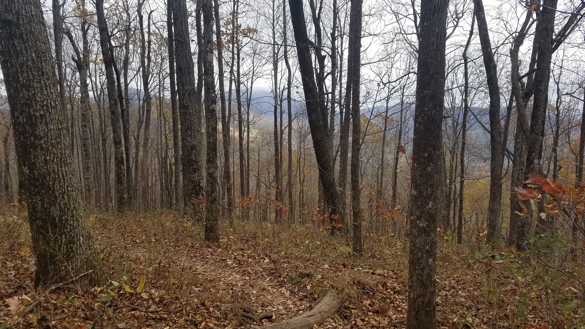
Best season to do this hike: Winter provides the best views of the mountains, otherwise much of the hike is through pretty boring forest.
Trails to Take
Start out at the parking area and go up the trail behind the pit toliet (yes, it is that fancy). The trail winds up past an area of unofficial camping. Keep following the white blaze of the Appalachian Trail as you climb, zig zagging across the side of the mountain.
Area of unregulated campsites
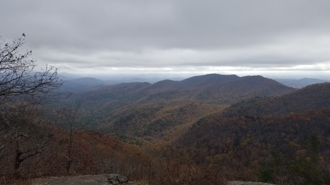
At a bout a mile in Preacher’s Rock comes into view, with a spectacular overlook of the mountains. Not quite as good as Blood Mountain, but it’s only a mile in to it.
Preacher’s Rock Overlook
Winter views in the woods
Beyond this the trail goes downhill, but not super downhill, and in another 2 miles or so you reach the Lance Creek Campground. There’s 3 or 4 tent pads, some bear hangs for packs, and I have it on relatively good authority that the sharp rocks sticking out of the ground are not a graveyard, but rather installed by trail maintainers to keep people from camping super close to the creek, (it was washing). Like most Appalachian official camping locations it has a water point marked if needed.
Pointy rocks that are not a graveyard but prevent camping
Campsites
BE WARNED
This is a high traffic trail and the parking area is often heavily over used. This can make it challenging for those with large vehicles or high levels of introversion.
In sum:
I thought going hiking would be safe. Turns out this stretch is a bigger Covid party than a frat house with a liquor license on a Saturday night after finals.