I once read that there is an old superstition that if the ravens ever leave the Tower of London then Britain is doomed to be shortly wiped off the face of the map. Britons, being apparently as practical as Carolinians when it comes to this sort of thing decided to hedge their bets by clipping the wings of the ravens at the tower so they could not fly away.
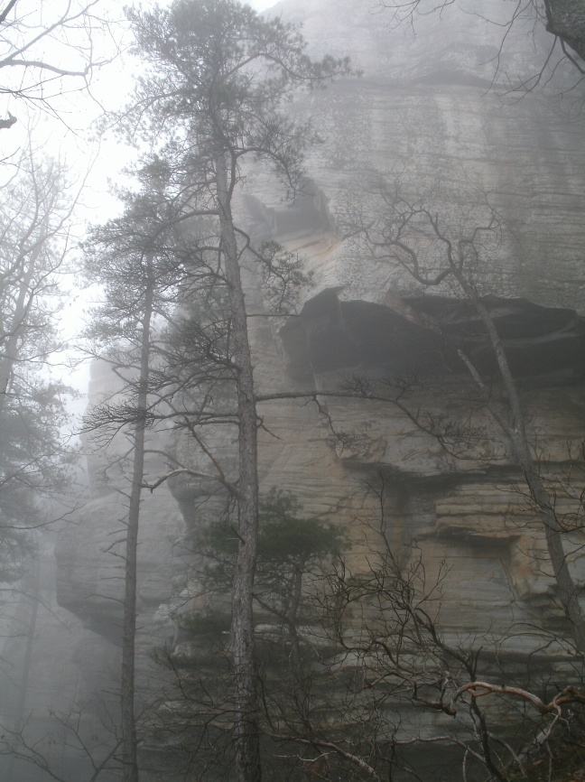
Pilot Mountain State Park is best known for the towering spire of rock that is its namesake. This rock was historically a major landmark, being used as a navigational aid by Native Americans and later by local settlers. It is also home to a population of ravens, (which is a bit unusual for the area). However, given that no soothsayer has climbed Jomeokee Trail and proclaimed immenent destruction based on augeries of raven flight these intelligent little fluff balls of black feathers are still free to come and go as they please. At least until one of them poops on your head.
_____________________________________________________
Location: Pilot Mountain State Park and the Yadkin River Section of Pilot Mountain State Park near Winston Salem, NC.
Is it goat approved? Probably not, but I literally unloaded my goat right in front of the park ranger and they said nothing…so probably not but no one cares on a cold Saturday morning? However, you’ll have to pick up after the goat in the parking lot, and this destination is very popular with families and family camping trips so there is a lot of non-goat savvy traffic. Be especially careful about Jomeokee Trail and arrive early! The park opens at 8:00, I was the first person to park at the summit at 8:45 in 50F with misting rain, but by 10:00 people and kids were really getting on Jomeokee and a whole pack train of people where loading out down at the main park office.
How you get there: Take Hwy 52 out of Winston Salem and watch for the signs to Pilot Mountain. To get to the Yadkin River Section plan for some extra time. You can access this area from Hwy 52 as well, but you’ll have to wind out into the country after getting off Hwy 52. Follow the signs for Home Creek Living Historical Farm as this is on the same road just before the turn for Yadkin River, (there are tiny “Yadkin River” signs stuck on the top of the road signs that are easy to miss).
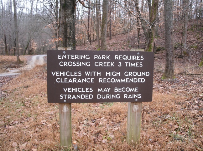
Parking at Yadkin River can be done off the paved road, (see maps below), or you can drive into the park and cross some creeks to get to other parking areas closer to the river. High ground clearance is recommended as these are rough car fords across the creek and the creek is prone to flooding during heavy rain, (and stranding people’s cars!).
Time for hike: The distance is approximately miles 4.4 miles including the Yadkin River Section (about 2 miles) and the Pilot Mountain Section (about 2.4 miles).Pilot Mountain is a loop hike over strenuous terrain. Yadkin River is an easy out and back hike. Further mileage for those who really want to hike and not spend all day playing with their camera like I did in the fog can be easily added at both destinations.
Best season to do this hike: WINTER. WINTER. WINTER. Pick a misty, miserably cold day. Don’t pick a downpour or the Yadkin River Section won’t be accessible and the rocks at Pilot Mountain proper will be really slick! However, the water keeps the climbers away and decreases the traffic at this tremendously popular destination. Unfortunately, if you go in rough weather the Pilot Mountain rock spire may not be visible, and the views of the surrounding countryside, which extend out to the Blue Ridge Mountains themselves may be obscured. However, there’s still lots to see and visit even then.
___________________________________________________
Trails to Take
Pilot Mountain Summit
To minimize the number of fellow hikers start off at Pilot Mountain State Park. Take the road all the way to the summit. While it would be fun to hike to the summit because of the time that requires and how many people would be at the summit when you finally get there, just bite the lame yuppie bullet and drive up. The drive is quite enjoyable, with twists, turns, and minimal guard rails.
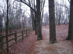
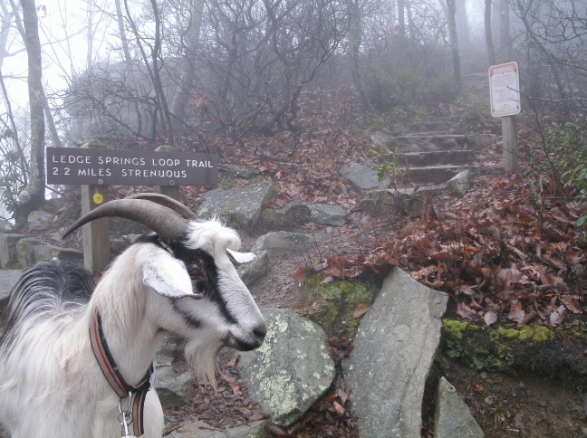
At the summit, you want to go down Ledge Springs Trail FIRST and then come back on Jomeokee Trail. Normally it would make sense to talk the highest traffic trail (Jomeokee) first, but due to the big, boring climb back up on Ledge Springs its actually still more fun to leave the busiest trail for last.
To get on Ledge Springs, walk across the parking lot to the cliff side, (away from the restrooms), which is mostly fenced off. Follow the wooden fence downhill through the picnic area and you will eventually leave the picnic area and get on the obvious Ledge Springs Trail, which wanders down to the bottom of the cliffs.


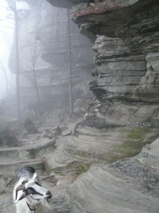
Ledge Springs eventually intersects with Grindstone, turn left to stay on Ledge Springs. The next half mile or so is stone steps and dirt trail running along the base of probably the best cliffs you can get east of the Appalachians. Mountain laurel and other plants more typical of the mountains are in abundance in areas that are not actively being climbed.
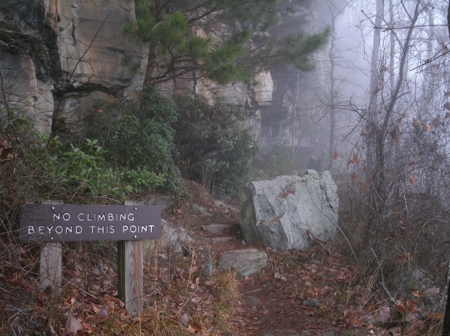
Not long after leaving the climbing area, (there will be a sign), the trail goes down a section of stairs and intersects with the *unmarked* Jomoekee Trail. I can only assume that the traffic is usually so heavy on these trails that they felt it unnecessary to make very clear signage about what trails are what, (because there would always be someone around to ask).
Turn right onto Jomoekee to go out to the rock spire that is the central show piece of the park. While the top of the spire is not accessible, (and climbing it is a misdemeanor), the trail makes a circle around the bottom. Accordingly, when the trail splits you can go which ever way you want – you’ll still end back up where you started.

There are numerous benches and picturesque cliff sides to view, and I ran into a few deer grazing at the base of the cliffs as well. However, it is important not to linger too long on this trail for two reasons. One, the loop is popular with walkers/hikers/kids with an increase in numbers over time, and two, there is a tight stair going back up to the parking lot. Once the circuit of the spire is complete, you can continue back on Jomeokee Trail past where you originally got on it and the trail will return you to the parking lot. However, if you are late in heading back and the traffic is heavy the tight stone stair back up to the parking lot may be too full of people for a goat and hiker to use…which sticks you with returning via Spring Ledge Trail and taking that long boring climb back up to the top instead.

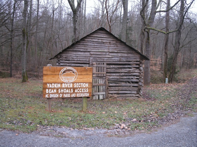
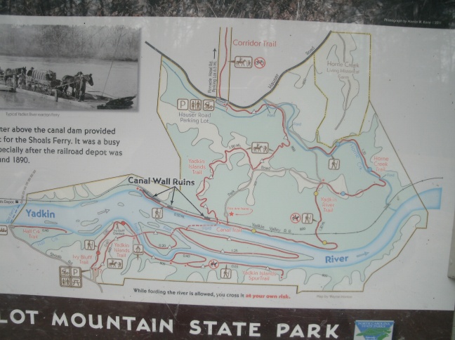
Yadkin River Section Canal Remnants
I parked inside the park just after the 2nd creek crossing where there is a large field for group camping, a pit toilet, a trail kiosk, and a rough parking area. Parking is also available at the end of the road after the 3rd creek crossing and off the paved road just after the turn off to go into the park.

From my parking location, I headed down the road towards the river, crossing the 3rd creek crossing. For some reason as you top the hill they have “no horses” signs posted, and you want to stay on the gravel road to continue, (since there are no “no goat” signs posted). The road eventually ends at a loop parking area with another trail kiosk which sports a much better map of the area than that provided online.
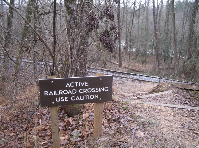
The entrance to the Bean Shoals Canal Trail is just behind the kiosk, (and easy to miss). Take this trail down hill to the railroad tracks. These tracks are active! So look both ways before crossing!

The trail joins a trail running along the river after crossing the railroad tracks. You can, in low water situations, wade this river, cross over the mid-stream island, and go hike the trails on the opposite bank from this point. If you aren’t into getting wet, go right and follow the trail as it winds along the bank. This will take you past the ruins of the canal wall. The rail line seems to have been built inside what would have been the canal’s actual waterway, (settling of the rail line at the far end of the canal demonstrates the issues with doing this!).

The shoals the canal was meant to help bypass are visible in the river to your left, as are numerous islands. At the end of the canal walls the trail just sort of fades out, and you can turn around and head back the way you came or walk back on the railroad tracks, (again – this is an active rail line!). Then head back to the car or take another trail to extend the hike.

BE WARNED!
- Ice was present on the trails around Pilot Mountain even at 50F, so if you plan to hike in the true dead of winter when there’s lots of that frozen stuff on the ground and hanging off the rocks be careful that you don’t fall to your death or get impaled by a 6 foot long icicle.
- The Ledge Spring Trail is where all the cliffs that people can climb on are located. Watch for falling debris, climbers lounging on/near the trail, and dogs belonging to climbers that may be tied to trees. They aren’t supposed to have dogs tied up to trees, but what park rangers can do about it besides shaking their fists up at their aerial enemy half way up the rock wall I don’t know. If it is raining or the cliffs are really wet and cold there don’t seem to be any climbers around.
- Jomeokee Trail is the primary trail that goes out and circles the big rock spire that makes up the focal point of Pilot Mountain State Park. This is THE trail for families, small children, dogs, and also the super serious peak climbing monsters with hiking poles and packs to all come together on. Clear this trail before 10:00 AM if at all possible.
- If you are bringing along people or goats who are not from the various parts of the world where active railroad tracks are also the main highways of adolescence to reach the swimming hole, main street, or Walmart, you might want to remind them that trains can’t break quickly and to look both ways before crossing the tracks.
- The top of Pilot Mountain, (that is, the top of the stone spire), is not accessible so as to protect the rare plant communities that live up there. I too was disappointed about this, but conservation should come first!
- The road to the summit is twisty enough and tight enough to exceed even the expectations of those veterans who have conquered the Blue Ridge Parkway, the climb to Caesar’s Head, and the millions of gravel roads snaking through Pisgah. It will add time to your commute to the trail head, and if there’s a lot of black ice and your tires are bald you might not get up the road.
- The Yadkin River Section has parking off S.R. 2072 (that is “State Road 2072” for those not familiar with North Carolina’s unique nomenclature). If you want to park inside the park though, like I did on this trip, remember that you have to cross 2 car fords through the creek to reach the first parking area and 3 fords to reach the second and third parking areas. Based on the marks on the creek bank that sign really isn’t joking about getting your car stuck because the creek is too high to cross. Bring vehicles with ground clearance and leave BEFORE the heavy rain starts.
- Unfortunately, if you go in rough weather the Pilot Mountain rock spire may not be visible, and the views of the surrounding countryside, which extend out to the Blue Ridge Mountains and downtown Winston Salem’s skyscrapers may be obscured. Fortunately there is still plenty to see even if these vistas aren’t visible.
- You will be stuck picking up after the goat in the parking lot areas of Pilot Mountain proper.
- The park opens at 8 AM (Pilot Mountain) and 8:30 AM (Yadkin River). Make sure you get there early and you will have the trails to yourself!
- Climbing the main rock spire at Pilot Mountain is a misdemeanor.
- At flood stage the Bean Shoals Canal Trail will be underwater as it runs along the bank.
In sum: If a tree falls in the forest does it make a sound? If the fog is so thick you can’t see them…are there still actually ravens living in the cliffs here?
