
Beech Tree Trail is about the most nondescript name you could come up with for a trail. It’s the equivalent of “Smith” for someone’s last name. There’s also the fact this particular trail is a circle to nowhere in the center of the woods that would generally leave one with the impression this is a skip it and forget kind of walk.
Nothing could be further from the truth. However you choose to get here, Beech Tree Trail is second only to the equally under appreciated Rocky Ridge Trail at Croft for quality ruins exploration, especially for those with a perchance for old homesites. Definitely worth a Saturday trip to investigate.
Important: while digging up historical relics in any state or nation forest is illegal, in Croft State Park it can be lethal if you hit buried World War II ordinance. Stay out of the dirt, on the trail, and away from anything metal sticking out of the ground.
Is it goat approved? Technically I have permission to be out here with a goat officially (though it dates from several years ago). The trail and the trails you use to access it are very goatable, provided you come down from Lake Johnson. Lake Criag is very peopled and may result in goat photo posing requirements.
How you get there: I would park up at Lake Johnson and take Foster Mill Loop around to this one if I were you. That’s the lesser of the evils.
Time for the hike: Beech Tree Trail (gosh almighty they should give it a better name) is a 2 mile loop with significant up and down in comparison to most of Croft’s trails. Break out the hiking boots for this one!
Best season to do this hike: Winter is usually the best for ruins exploration because the leaves won’t be in the way of seeing the ruins, but you could do this any time of the year.
Trails to Take
The turn off Foster Mill Loop and onto Beech Tree Trail is located at 34.869111,-81.829531. It can be a little annoying to figure out because you turn onto the trail and then kind of turn again (which changes depending on what direction you’re approaching from). So watch for trail signs. The first little stint of trail is boring and generic, but you’ll quickly start going up and down along the edge of steep hillsides with rocks jutting out from the earth in places and drop offs. In this area I saw two deer and what looked like a fox high tailing it through the shrubbery – further signs this isn’t a high traffic route. An unbelievably muddy creek crossing is also included in this stretch, but can be overcome by choosing the wider of the two routes people have made across this erosion created mess.
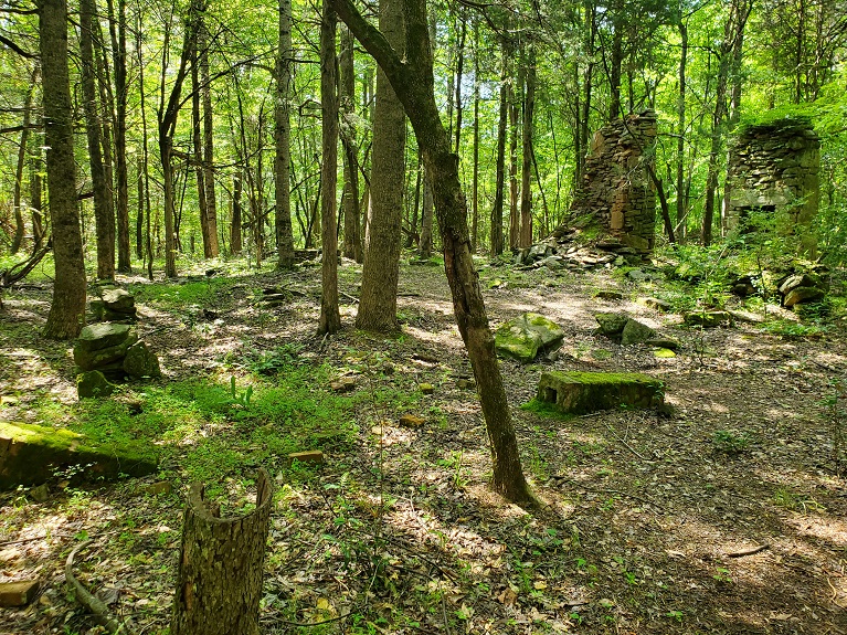
Starting at 34.862547,-81.823066 as you walk around the loop you’ll first reach some faint buried foundations the trail walks right over as well as a suspiciously large oak and old juniper tree – signs that this area used to be open. Then the spectacular remains of a two story and very large farmhouse come into view. The two chimney stacks are still partially in residence, as is what I believe to be a filled in hand dug well bore just behind the chimneys that once had a structure around it. The concrete steps and the remains of pillars that supported the structure both stone and brick lie among the leaves. The road that serviced the house remains as a clear imprint in front of the steps. From here it only gets better – a second chimney, perhaps from a farm hand house, lies just down the hill on your left as you continue on the trail, along with an obvious and now quite short stone built terrace the trail climbs right over. A third house or structure, with only its concrete steps remaining, lies to your right between this trail and the Foster Mill Loop that’s passing nearby. A connector trail to Foster Mill Loop will lead you right past it. There’s also a concrete foundation out in the woods to watch out for, with no real hint as to what warranted the expense of the foundation to be seen. Possibly a generator, spring house, or fuel shed of some kind.
The trail continues, coming up along the edge of a hill (the hill descends to your left). It crosses faint terracing, then a double sided ditch of unknown function that runs across the trail from uphill, across the trail, and then downhill. The remains of a fence or boundary line possibly. The last vestige of the farm is a huge pile of stone in an irregular mass below the trail – this is probably the remnant of stone clearance of a farm field, which is done to increase plowability and fertility of the soil. It’s a time honored way to make a better spot to grow things, and also a traditional punishment for wayward children. Feel free to imagine how many bad things you had to get up to as a child to accumulate that many stones :).
The rest of the trail is fairly mundane. A windstorm or minor fire has cleared some of the forest and a tangle of bushes and sporadic trees has resulted, which is a nice break from the monotony of the forest, though the views created by the clearance aren’t much to speak of. The trail re-enters real woodland, then comes up alongside Foster Mill Loop once more to complete its circle to nowhere.
Large house site

Old well bore behind the double chimneys

Structural wall adjacent to well bore

Front steps (road bed is just behind me)

Second chimney of smaller house site

Rockwall trail crosses

Concrete foundation out in the woods

That weird double sided ditch

Huge discarded rock pile that may be from field clearance

In sum: Yeah, my rock pile from childhood wasn’t that big. I guess I wasn’t as mischievous as the brats on this farm.
