
There are trails for which there are no maps. You find out about them from word of mouth, or possibly just by stalking someone who looks like a local when they dive down what appears to be a game trail and turns out to be a path of such spectacular spender that you begin to feel that you might have accidentally fallen through a wardrobe to an impossible fairyland. Their names, when they have them, invariably are far less amazing than the places they go and are generally based on the local topography, (“Gorge Trail”), what road they’re on, (“Guion Farms Trail”), or for the most literally minded, how hiking them makes you feel after a while, (“Dismal Trail”). Welcome to the wonderful world of the undefined and exploration rich hike that is traversing “social trails”.
Location: The area northeast of the South Hill Recreation Way, which encompasses the old drinking water reservoir and water pipes, the current drinking water reservoir, the Wildflower Preserve, several dams, the unofficial nudist beach, and an absolute maze of old and new social trails.
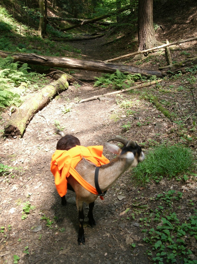
Is it goat approved? Yes. These trails are “social trails” so there are no hard and fast rules. However, accessing this area through the Wildflower Preserve or South Hill Recreation Way will require the goat to be on leash, (in theory). Off these official trails I would almost recommend keeping the goat off leash, since sections of the route are really more like walking through the woods than on trail, with the concomitant issues of tree climbing and general silliness.
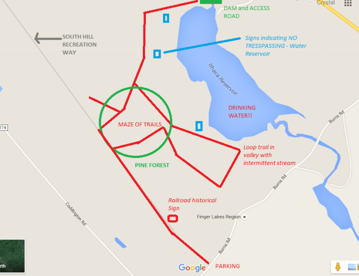
How you get there: You can enter this maze from several directions, but the easiest is probably to start by parking off Burns Road, near the intersection with Coddington Road in Ithaca, NY. Look for the gravel pull over and the trail head for the South Hill Recreation way.
Time for hike: Something between 1 hour and most of the day depending on how much exploration you are interested in doing.
Best season to do this hike: All year, but buggy in summer.
Trails to Take
*Solid red lines on the associated maps indicate clearly defined trails. Dotted lines indicate poorly defined trails, general directions to hike, and trail areas that are subject to shifting a lot*
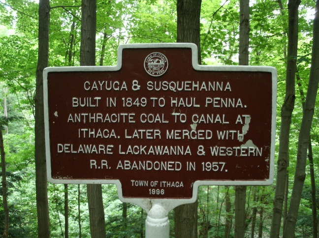
Start off at the trail head off Burns Road. Walk down the gravel road that is the South Hill Recreation Way. You will pass a historical marker discussing how this trail used to be a rail line.
A ways down the trail, a patch of pine woods will come up on your right. Start looking for unmarked social trails going off into the woods. The last time I was out here the trails going off the Rec Way in the vicinity of this patch of pines were the shortest route to get down the reservoir. Things may have changed. Continue down into the woods, trying to keep north to northwest on any social trails you encounter, but always heading away from the Rec Way. Avoid taking trails that pass by the “water reservoir – no trespassing” signs as this will take you too close for comfort to the current drinking supply. Eventually you should hit upon a well defined trail going off to your leftish/northwestish along the ridge above the water reservoir. If you miss this turning you’ll end up in a maze of trails that makes a loop on the south side of the reservoir before sending you back to the Rec Way.
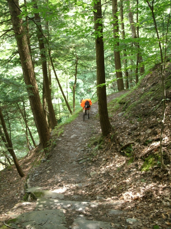
Assuming you find the ridge, continue until you reach the reservoir dam and the outflow of the river. Then turn left off trail, and climb down the steep slope along the edge of the gorge. This is a bad area for loose rock – avoid the easy route of climbing right along the very edge of the gorge! Don’t hike with the goat on leash here, since you want it to die of its stupidity without taking you with it.
At the bottom of the hill there is a section of river with large stones that is popular for swimming and sunbathing. Stay on your side of the river and continue along the river edge following a poorly defined trail. You will pass through an area of mud and small springs/streams.
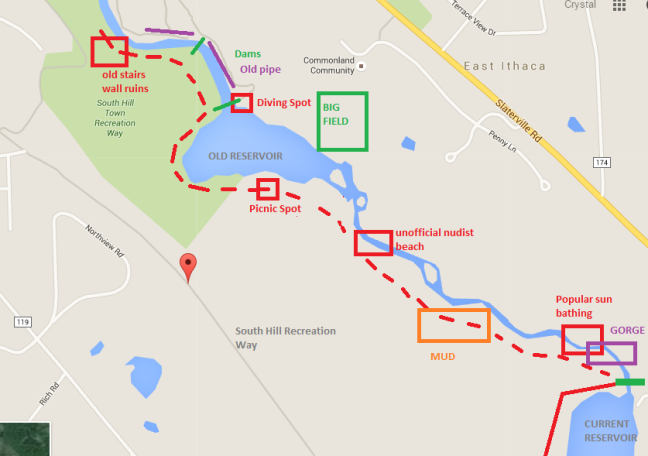
The trail will become more defined, eventually leading down to a ledge of rock that you walk along and a very rocky area of the river. This, I have been told, is the unofficial nudist beach for Ithaca. Beyond the nudist beach is the pond/old Ithaca water reservoir. The trail climbs up hill, stopping at a picturesque clearing with a good view of the pond. Across the pond is a large field.
Continue along the edge of the pond on a mostly overgrown trail with excellent goat forage but also lots of snakes. Eventually you will reach the pond dam, a popular swimming location, and the cliffs above it are popular diving locations for the local youth/hooligans. There is the remains of a water control building, and old water pipes are visible across the river. Continue along the edge of the river, passing by a second dam along with an excellent fishing hole just below it.
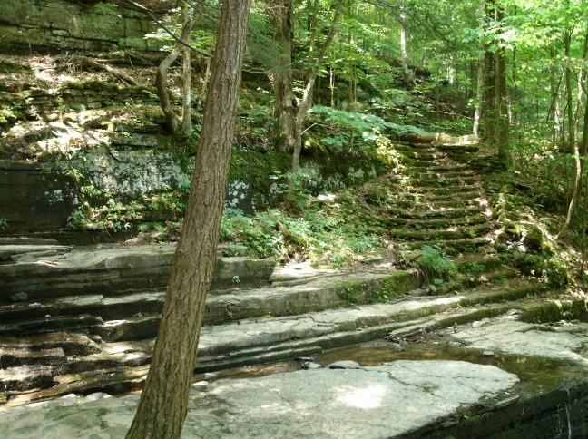
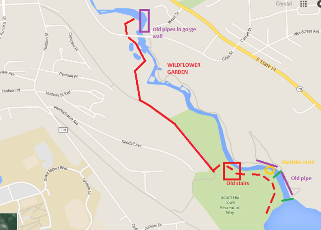
The trail will become much more defined and begin to feel “old”, (that is, like it was intentionally built). Ruins of walls and in one area, a quite nice set of stairs, will be passed. Look for trails heading up hill from the stairs, and follow these into another maze of social trails, eventually culminating in reaching the South Hill Recreation Trail again. Walk down the trail, or parallel to it on a social trail, until the hill becomes very steep, with the river in a small flat flood plane below it. As you near the end of the Rec Way a gravel road in varying states of disrepair comes off the trail and goes down the hill. This, or a social trail near it, leads more or less to the small water treatment plant along the river. Find a way down to this water treatment plant, (it sits right on Giles Street).
Walk around the treatment plant, and directly across Giles Street from it is a gravel road that is usually barricade by a gate or rope or something. Cross the street, go around said barricade, and continue down a really really steep gravel road. The road goes around a hill, and drops you off at the river. Across the river, in the cliff faces, is some amazing old ruins dating from when the old reservoir was still in use, (apparently a different piping system is now used for Ithaca’s water). Then, turn around and head back, or across Giles Street bridge and explore the opposite side of the river!
Be Warned!
- This hike takes you near the CURRENT DRINKING WATER RESERVOIR FOR ITHACA. For those not up on basic public health, taking an animal, (or human), and letting it defecate near the place where your drinking water comes from is not a great idea. A fascinating example of prior mistakes in this area in Ithaca is the major 1903 Typhoid epidemic which killed hundreds, including Cornell University students, when the local water supply was contaminated with typhoid due to poor sanitation and possibly by asymptomatic typhoid carriers working for the water company. Needless to say this water company went bankrupt in the ensuing death and carnage, but the remains of this system’s piping can still be seen in the area. Ithaca still derives its water from the same dammed river that started the epidemic. Those who forget history are doomed to repeat it. Possibly with the assistance of a goat. So keep your distance!
- These are social trails. This means that they are defined by social consensus, and as a result, that these trails may change in their location and where they lead over time. Be prepared to find my rough map is very nearly entirely inaccurate, not because I have it in for you, but because a bunch of other people, I guess, have it in for you!
- This hike leads along the edge of extremely unstable gorge cliffs composed of rock that has a bad habit of randomly falling to pieces under your feet or in your hands. Remember that only you can prevent your own embarrassing and excruciating demise. Stay away from the edge, don’t attempt to climb, and don’t follow the stupid goat who wants to do any of the above.
- This trail will require climbing “strenuous” hillsides.
- Watch out for snakes around the ponds.
- If you are easily embarrassed, watch out for nudists on the river.
- Be prepared for lots of off leash and out of control dogs.
- Be prepared for hippies, spiritualists, New Age shaman wannabes, and adults building club houses of out of tree branches and vines. This is Ithaca after all.
- There is a woman who walks the recreation trail that is deathly afraid of goats.
- There are tons of little creeks crossing the hike that Google appears to be ignorant of. Be prepared to get wet and muddy!
In Sum: The greatest secrets are the ones you discover for yourself, [or insert another boring fortune cookie-esque platitude of your choice here]
