I once spent a very odd evening watching my husband play RISK (a board game of world domination) with his coworkers. The *ahem* winner *ahem* of this board game was a very nice and very german guy who choose to start out in:
A. Germany
B. Playing all the black pieces
C. Then proceeded to wage a nasty and bloody campaign of lightning destruction across the entire world map culminating in the unabashedly brutal subjugation of even his own wife while taunting the rest of the players for being inferior.
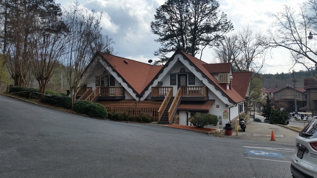
For a less…awkward…outing with your coworkers, check out Helen, GA – a rather embarrassing tribute to the only other things we Americans know about Germany – that it has fancy pastries, odd architecture, and lederhosen.
Oh, and outside this fake german town are some cool waterfalls.
The German bakery in Helen, Georgia
Is it goat approved? I’d keep the goat at home for this one, unless you plan to teach it how to yodel.
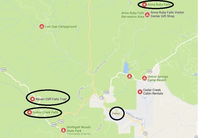
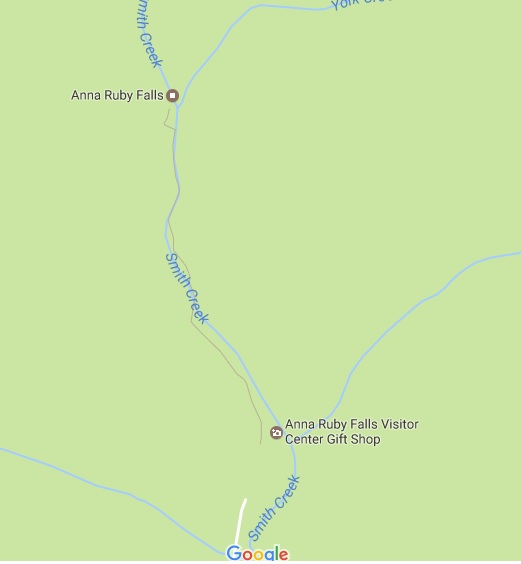
How you get there: These hikes are all in the Helen diaspora. Google Helen, then google Duke’s Creek Waterfall, its next door neighbor Raven Cliff Falls, and the famous Anna Ruby Falls north of Helen.
Raven Cliff Falls Parking:34.709535, -83.789066 (4.9 miles round trip out and back)
Duke’s Creek Falls Parking: 34.702030, -83.789232 (2.2 miles round trip out and back)
Anna Ruby Falls: 34.757196, -83.710484 (1 mile round trip)
Time for hike: The distance for this hike is 8 miles to go out and back to Duke’s Creek, Raven Cliff, and Anna Ruby Falls in total. Plus however much walking of the pseudo-german town of Helen, Georgia you are interested in.
Best season to do this hike: Spring or Fall. Avoid Oktoberfest because it raises the DUI rate and the traffic. Avoid summer because, well, where else are people going to go for a good time than a beer garden in Helen?
Trails to Take
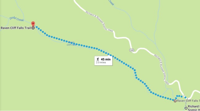
RAVEN CLIFF FALLS
An easy trail winding along the river from the parking area to a final climb to the falls.
Raven Cliff Falls
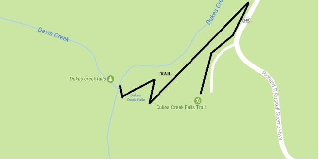
DUKE’S CREEK FALLS
A continuous downward run with several switch backs. The climb back out is not hard, but continuous.
Duke’s Creek Falls
ANNA RUBY FALLS
An easy uphill culminating in a very busy end platform.
Anna Ruby Falls
BE WARNED
Anna Ruby Falls is $3 a head to get in regardless of how you get in, (car, walking, etc.) and is very popular. Go during an unpopular time.
Duke’s Creek Falls is $4 a car to park, (its self service pay though). Raven Cliff Falls, its next door neighbor is free however.
Helen, GA requires a $5 fee to park, though if you park behind the Hofer’s Bakery and get a spot its free so long as you are on the premises.
For those into wildflowers check out the trilliums on the Anna Ruby Falls Trail.
Anna Ruby Falls Trail trilliums
In sum:
RISK is a game of world domination that teaches you a lot about your coworkers and the countries they come from.
Never challenge anybody from Germany or Africa. Ever.
Columbia, South Carolina is not the location most people would pick if you said to name a place rich in history. Which kind of makes it a secret! Only in the last fifteen years or so have the numerous ruins and historical structures been brought to wider appreciation. One such gem that the people of Columbia have recently rediscovered is the 1891 canal that once brought cotton bales around the rapids on the Broad and Congaree Rivers. It is a great place to spend an afternoon bomb proofing a baby goat and rediscovering some history for yourself.
If you are interested in more less well known Columbia history check out Underground Columbia, the mill ruins at Riverbanks Zoo, and the network of underground tunnels beneath downtown Columbia that are currently used for storm drainage. Note these are not goat friendly…
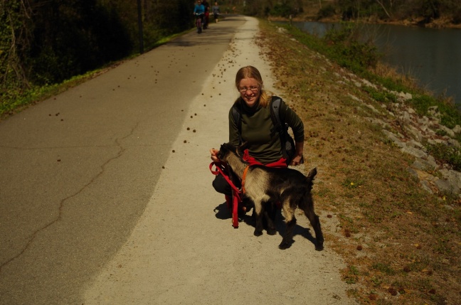
Is it goat approved? Yes, at least for kids. The park ranger seemed amused
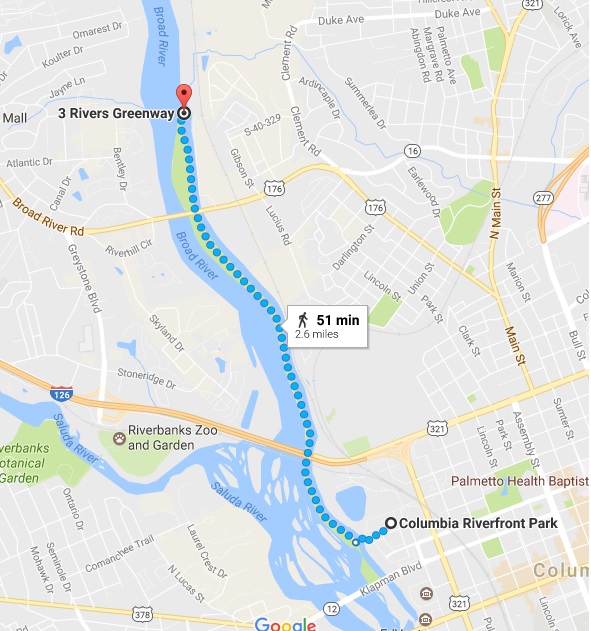
How you get there: Google Columbia Riverfront Park. That is the parking location. Yes, it is a ritzy looking spot for being right next to the water and sewage treatment plant.
Time for hike: The distance for this hike is 5.2 miles out and back to canal locks for the historical Columbia Canal.
Best season to do this hike: Any time but dead heat summer. Its easy, it’s flat, and it is going to be coated in people regardless of when you go, so you might as well please yourself in terms of the weather.
Trails to Take
There is really only 1 trail – it goes along the original tow path for the canal. To reach it there is a paved trail from the parking lot which starts near the red school house building, (this is an original school house built in the area).
Training on the canal walk
The paved section descends down between the water treatment plant and the original retaining wall for what was once Columbia’s oldest, largest, and certainly creepiest jail. The Central Correctional Institute (or as my parents referred to it, the Columbia Penitentiary) was a massive granite block structure that was in use for 150 years until finally being decommissioned in 1994 after decades of complaints about how outdated the facility was. For a while you could take tours of the place, and my parents were fond of retelling stories about the walkways without rails, some of which were many stories off the ground…and how unpopular inmates were pushed to their deaths from these. The obviously very ominous and atmospheric jail, with its wonderful rusting razor wire fences, intact guard towers, looming stone walls, and even an inmate baseball diamond, was demolished several years ago to make way for some hideous cookie cutter condos. But the retaining wall is still impressive, if less creepy.
Inside the jail before it was demolished. Note the very long drop from the upper floors…
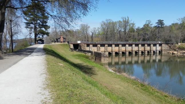
The trail crosses over the canal itself a metal I beam bridge, to join the canal walk. Directly across from the bridge are the original Columbia Water Plant pump houses, which supplied water from the river to the city of Columbia until the modern water treatment plant was built. The modern water treatment plant lies on the opposite side of the canal and draws its water from the canal instead of the river.
Inside a pump house
outside a pump house
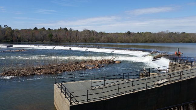
dam with weir and power for pump houses
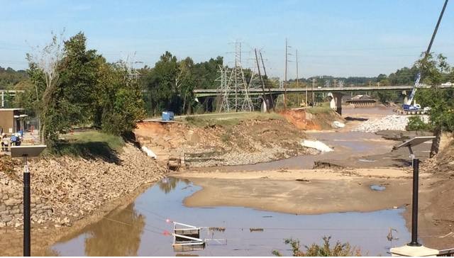
To the left of the pump house buildings is the dam that powered the historical water plant and also contains the waste weir for the canal. Waste weirs are used to drain canals for repairs and to adjust water level. Unfortunately, this system was insufficient to keep the canal intact during the devastating 2015 floods, and damage to the canal, including a wall breach, is still being repaired. Interestingly, the canal we walk on today is the 1891 canal, but the first canal in this spot (built in 1820) was also destroyed by a flood. Given the nature of the Broad River to stay “broad” by flooding several times a year I suppose canal damage is inevitable.
2015 flooding punched a hole through the canal wall and drained it
In the distance you may be able to spot the Columbia Cotton Mill, which is today the State Museum, and Gervais Street Bridge, hands down the prettiest route into Columbia. There are further canal and industrial ruins between here and these landmarks, but for whatever reason they had this section of the walk locked off today.
Diversion dam that feeds water into the canal
Following the paved canal walk away from the water treatment plant and down the original tow path you pass under a rail line and highway bridge and by several overlooks. The canal today looks very different from when I first walked it 20 years ago. Back then it was, in the words of my hiking elder and grandmother “kind of dumpy” and significantly less busy. Today the thorny undergrowth is gone and you can see the river and the canal for almost the entire route. There is a small paved trail that comes off that you can take to get closer to the river, which is popular with fishermen and highly recommended because it sees less traffic and lets you get up close and personal with the water and the rocks of Broad River. In the spring, watch for the protected shoals spider lily, which blooms out among the rocks.
The canal lock
The walk is easy, flat, and unless you are into swimming you can’t get lost. The tow path terminates at the restored canal locks. 20 years ago this area was fenced off, but now you can walk across the locks to an upper parking lot and there’s an actual plaza to overlook the diversion dam that feeds water into the canal. This spot is popular with fishermen and with bird watchers for the abundance of feathery mayhem that collects at the diversion dam.
Then turn around and head back.
BE WARNED
Traffic is heavy and parking is tight at Riverfront Park. Bring you something small and people friendly for this one, (and be prepared to pick up after it).
Apparently they have problems with alligators in the canal now. Avoid feeding the goat to the wildlife.
While this is such an urban walk the backpack and hiking gear will be unnecessary and totally out of place, bring a water bottle if you are going in summer – the asphalt bakes you to death.
The area is patrolled by bored park rangers. If you need to avoid the rangers go to the new parking area at the canal locks instead of going to the one in Riverfront Park. However, the ranger I ran into did not seem bothered by the baby goat.
In sum:
Water manager during the 2015 flood: “Nobody panic okay, but I think we just poked a giant hole through the canal supplying all of our water…”
Talladega National Forest is a bit of the mountains in the middle of the plains, but for most of this trip to its northern tip you’ll feel like there’s more pine trees than rocks and elevation. And like the favorite anthem of Alabama state pride the ride in is pretty sweet – sliding around on white gravel roads weaving off through controlled burn pine forest.
The only downside is it might make you nostalgic for places whose full address is not only in space, but also, alas, in time.
Is it goat approved? Yes, I have official permission to hike with a goat out here. Thank you Talladega National Forest!
How you get there: Parking is at Pine Glen Campground – google it! The last several miles in will be a series of poorly marked gravel roads (look for brown forestry signs for the road number). Oh, and the Skyway Motorway is not fancy here – its just a bigger gravel road than the rest of them. Over all the general road maintenance is excellent and even low ground clearance vehicles won’t have trouble.
Time for hike: The distance for this hike is 6 miles out and back to Sweet Water (yes, that is really the name, I know it sounds like something out of a made for TV movie) Lake.
Pinhoti Trail Marker
Best season to do this hike: Any time. Its easy, it’s flat, and it is mostly shaded. You will probably encounter more activity in the summer as it ends at the lake and starts at a fairly well maintained rustic campground.
Trails to Take
The trail starts across the bridge from the parking at the campground, and follows the river. The blaze is blue, and this is also the Pinhoti Trail but instead of Georgia it is the Alabama Edition.
Wildflower
Old Stone Wall
Fire cleared pine forest
The trail meanders along a series watercourses and climbs several times up through fire cleared pine forest. A few wildflowers and a flat, placid river are the main points of interest. There is also an old stone wall just before the trail heads up hill for the final climb to the dreadfully named Sweet Water Lake.
Sweet Water Lake plus a less preteniously named goat
Just before the lake the trail passes through a fun little field of yellow grass that may make you feel like breaking out the katana if you’ve been watching too many bad martial arts movies lately, then the lake comes in to view.
The field – a good spot for a goat lunch
The trail takes its time along the lake shore, and the turn around point is the road down to the small boat ramp.
BE WARNED
Parking is limited at Pine Glen Campground. As in like only 3 official spots for hikers at the entrance…and in winter I got the last spot.
The Pine Glen Campground (and thus your car) are in a flash flood zone. So is most of the trail. Maybe not a great spot to hang out if its raining and stuff. Especially since the last water course before the lake also appears to be the drainage for the lake.
To hike with goats the park requires that goats be fed with weed free hay for 96 hrs before you arrive. I use a heat treated timothy/alfalfa blend chaffe hay in place of my usual stuff for this.
In sum:
When the welcome sign to your state says “Sweet Home Alabama” it means you recognize you’re the source of the only politically correct anthem for the South. And you’re a tad smug about that…