
Cornell has many trails winding through campus, the gorges, and Ithaca proper, but if you are looking to get out into the woods without actually getting out in the woods, (because you will definitely need to be back in time to get stuff out of the autoclave/mass spectrometer/QPCR/etc. in a few hours), the curiously named “Monkey’s Run” system of semi-social trails is your best destination.
Right on the edge of Cornell’s campus, with an abundance of trail heads and parking to fit even a graduate student or lab technician’s limited free time, this trail is a great way to spend a few hours or a whole day getting out from under the fluorescent lights, off the linoleum floor tiles, and back to nature.
Location: Monkey’s Run Trail System, known by numerous other names, next door to Cornell University.
Is it goat approved? Sort of. There is no rule against goats, and while technically they should be leashed the large number of off leash dogs you will encounter in the area tends to mean that most people you meet will overlook your goat being off leash. I would have the goat leashed when crossing through the community gardens and crop fields, however, as tasty stuff tends to make goats go temporarily deaf.
How you get there: I like to start across the road from the Cornell Plantations, at the gravel pit and suspension bridge, (GPS coordinates 42.454538, -76.455103). There is a gravel-esque pull off at the trail head you can park on.
Time for hike: Something like 7 miles round trip according to Google, but there are numerous turn offs and side trails to explore, so expect to spend more like 12 miles to do all the side trails available. This is a loop hike for the most part.
Best season to do this hike: Fall and Spring are best, (especially during wildflower blooming!). In winter the snow and ice can turn it into a slide and slog suffer-fest and in the summer there’s too many critters of both the bug, dog, and homo sapiens varieties.

Trails to Take
*These are essentially social trails despite the orange and red blazes and the hard work of those that maintain this network. Use my trail maps as a rough guide to where trails are as maps are drawn purely from my memory without the aid of GPS or something that might actually have a prayer of being fairly accurate. *
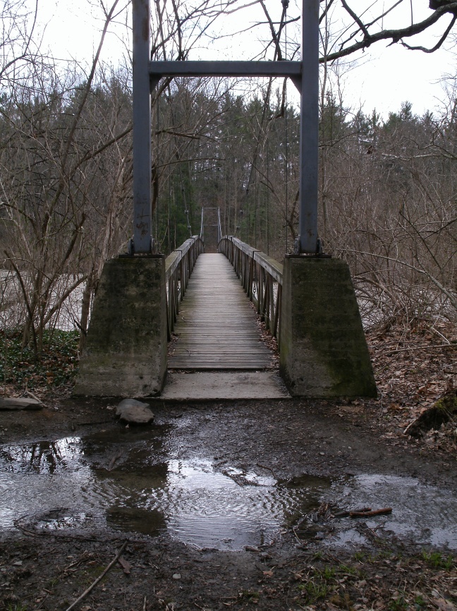
Starting at the suspension bridge near the gravel pit, you want to cross the suspension bridge and immediately turn right, (there is a trail that comes off to the right before you cross the bridge that is a nice side trail, but not a main part of the hike). As you continue along the river look for a trail branching off your left that heads for the hillside, and continue taking any trail that sends you towards the hillside. The trail you want will meander a little bit before heading up hill. As this trail approaches the edge of the woods another trail will come off to your right. This is a loop trail that just goes along the hill top. Take it or ignore it, but it’s really just a side trail. The main trail leaves the woods and runs along the edge of a horse pasture, with a big field to your right.

The trail ends into a road. To the left it runs into the horse farm, so you definitely want to go right. The road runs past agricultural fields on the left, and a crosscountry jump field for horses on the right. It will pass through a small copse, then drop you off in the parking lot of one of the apiary buildings, (easily identified by the bee hives in the vicinity). Cross the parking lot and walk over Freese Road.
The trail is marked by orange blazes and skirts the edge of the Cornell Community Gardens, running along the tree line. The river will come up on your right, at the bottom of some very sheer cliffs. The trail continues along the river and is exceptionally easy to distinguish even without the blazes. This cliff edge can be unstable, so let the goats go over and look down if they want but don’t give into the temptation to do the same.
The trail wanders in and out of the woods, then descends a very steep set of stairs to the edge of the river. Take a good look at this place! This is where you will cross the river on the way back unless you want to do a little river walking and swimming. The footing in this part of the river tends to be very good, free of holes, and generally not too deep. However, if the river is obviously flooding you may not be doing the full loop today!
The trail continues for what rapidly begins to feel like FOREVER along the edge of crop fields, woods, and horse pastures. Eventually the trail will come up alongside some park buildings/picnic shelters and cross over a small bridge. At this point start looking for a trail heading very sharply DOWN HILL. As you approach this downhill you will pass a stand of human planted pine. A short cut trail cuts through these trees that you can take if you don’t want to do the big downhill and walk around the hole curve of the river.
If you do want to walk down the river, find the downhill, take it, and continue along the river. You will pass the remains of an old road and bridge. After following the river the trail will strike out up hill, bringing you up to what feels like an abandoned dead end road. As you walk along the old road way look for a trail going off to your right into the woods. You want to take this trail! If you get to the parking lot you’ve gone way too far and should turn around and head back.

This trail continues to meander along the river, eventually coming up to a powerline cut near Hwy 13. The river is pretty deep here, so if they haven’t built that fancy pedestrian bridge they keep talking about yet, jump the guard rail and cross on the highway bridge. For goats that have not been on main roads this will freak them out, especially if an 18 wheeler happens to come by while you are crossing. If you brought a 2nd human and more than one goat, walk each goat across one at a time.
On the other side of the river do a short hop through the woods back into the powerline cut and keep your eyes peeled for an orange blaze marking the trail. Alternatively, continue up the powerline cut until it reaches a large and obvious utility right of way that is also a well used greenway that you can take back in the right direction too.
If you take the trail instead of the greenway, you will wander along the river again, passing a trail or two that heads off up the hill, (and connects up with the aforementioned greenway). As you approach the old bridge again the woods will thin out with signs of beaver activity, (and signs of humans trying to STOP beaver activity). This is a beautiful area for wildflowers in the spring. As you reach the old bridge another trail will head off to your left up what appears to be the continuation of the old road bed. This goes up to the parking lot off Monkeys Run Road and to another side trail you might be interested in.
The main route continues along the picturesque river, passing a few side trails that can be taken, including a loop trail that overlooks the Cornell research fields. As you walk, keep an eye out for the place with all the stairs you were at earlier on the opposite side of the bank. There is a large rock on the shoreline that makes a very handy marker. For the less intrepid explorer, when you reach this spot, cross the river and go back the way you came in the morning to return to the car.
For those of a more adventurous, insane, or just mildly stupid demeanor, continue along the trail. Shortly after passing a moderate sized island midstream the trail will turn, pass a pile of old gravel, and dump you out on the gravel road that runs around the Cornell research plots. To continue back to the car, you will need to walk in and along the river, (as indicated by the dashed red lines on the map). This part of the river is prone to holes, so take your time. You will need to zig zag from bank to bank as you go along.

The river will lead you up to the steel bridge that Freese Road runs across. You cannot, no matter how much you want to, cross the river on this bridge because it has a grating floor that goats can’t walk on. You cannot, no matter how much you want to, cross earlier to be on the right side of the river prematurely because that will have you crossing a bunch of private property. What I have successfully done several times is climb the bank just before the bridge on the Varna side, cross Freese Road, go back down the bank, and then very carefully wade or swim depending on the condition of the river bottom, across to the other side. This area is prone to developing VERY deep holes because of the bridge pylons, so take your time, and above all, take goats that know water.
The opposite bank is a tough climb, but doable if you and the goats are lightly loaded. At the top, continue along the left side of the road a few feet, and turn at the gravel drive next to the house. This leads down to another parking area and entrance to Monkey’s Run. You can take the trail from here back along the river to the suspension bridge and thus, the car.


Be Warned!
- Hunting occurs in the area during deer season. Deer poisoning has also been periodically used to thin the herd in Cayuga Heights, so if you see something that looks like a deer bait station keep the goats away!
- The Cornell research fields are technically off limits to non-researchers, but I hiked them for 3 years without so much as a peep from anyone. However, respect goes a long ways – if you want to hike this area keep your dogs/kids/goats out of the research plots and on the gravel road! Graduate students can get really pissed if you screw up their research plots and delay their dissertation! Of course, if you yourself are a graduate researcher and any of your committee members are plant science guys, remember that politics in academia can be very harsh, especially if your goat eats up an entire USDA’s worth of grant funded alfalfa.
- If you walk the river watch out for holes, (that is, big nasty deep drop offs in the river), especially as you near Freese Road. Goats and people occasionally fall in these and have a hard time not drowning. Drop offs may form where there weren’t any before after big storms or snow thaws.
- You cannot cross the Freese Road bridge with goats. It is a single lane iron grating bridge! Don’t even try it! If you have a pygmy or something you *might* be able to carry the goat across, if the cars actually wait for you.
- Swimming and letting the dogs off leash for a dip is very popular near the gravel pit. Plan you trip to AVOID this area if the weather is nice for a swim.
- Large flocks of angry housewife types with dogs and small children may be encountered near the suspension bridge mid-morning in nice weather. Avoid them because they’re unhappy that they have to go jogging with all those dependents to avoid gaining weight and their unhappiness will be vented in your direction.
- The Ithaca branch of the ASPCA is off Hanshaw Road, and you will pass the area where they take the dogs up for adoption out for walks. These guys are usually on leash, but keep an eye out.
- Technically goats (and dogs) should be leashed on all the trails in the Monkey’s Run system, but Ithaca has a generally relaxed attitude to dogs being off leash, so goats off leash are generally tolerated.
- Please note that these trails are basically social trails and the maps provided are from my memory of hiking the area. They are not completely to scale, nor likely to be totally accurate when you visit the trail in person. Expect the unexpected!
- Be kind so that others might cut you some slack too. A fair number of very casual young hikers go out to Monkey Run and underestimate just how far you can walk down the river, (or become engrossed in the scenery). It is moderately common for them to accidentally exceed the mileage they really meant to do. If you see a bunch of kids that are half dead walking down Hanshaw or Freese Road consider letting them squeeze in with the goats for a ride back to the trail head they started from.
- In theory no bikes are allowed on this set of trails. However, you will occasionally find a mountain biker trying his luck. Be nice. In theory he shouldn’t have to deal with goats either.
- The cliffs above the river can be unstable. Dying from stupidity is very embarrassing!
- Don’t try crossing the river at flood stage or on ice. Duh. Again, dying from stupidity is very embarrassing.
In Sum: Life shouldn’t be all in the research lab. So turn off the cellphone, put the dust cover on those graduated cylinders, and hang your pipetter up for a quick trip to the woods.
